Fishing Offshore Reefs & Shipwrecks

There are thousands of reefs offshore on the Gulf of Mexico, the Keys, and on the Atlantic coast. Most of the Florida offshore reefs are Artificial Reefs which are man-made by either the local county or the Florida Fish and Wildlife Commission.
Florida has the worlds third largest natural reef system in the world and the largest number of shipwrecks that crate artificial reefs. Widely scattered patch reefs are found around the state providing habitat for our fisheries. Leaving from any dock, you don't need to go far to find a reef or wreck. Many Counties around Florida have their own Artificial Reef programs in addition to FWC's, so we have done our research and put all the lists together in one place on our Reef GPS Coordinates pages.
Where are the Best Reefs?
As far as telling which reefs are best around the state, that is something you can have fun figuring out for yourself. I have a few spots I like, the locals have theirs, and the charter fishermen who have the most success fishing reefs are tight lipped as to where they are. One thing I do know, July and August are the start of the prime months when Permit and Kingfish will be on the wrecks.
Fishing offshore reefs is a very popular destination for visitors and locals alike. The easiest way for a visitor to our area to fish a reef is to hire a Charter Boat, this ensures a success fun day of fishing our reefs. Visit our Offshore Fishing page for details and tips on How to Fish our Reefs.
![]()
Get the Free lists of reefs, wrecks, fishing hotspots, islands, way points with GPS coordinates from Florida Go Fishing,
visit our Florida Reef GPS Coordinates page.
027_small.jpg) |
050_small.jpg) |
|---|---|
012small.jpg) |
011_small.jpg) |
|
|
Fishing on a Reef
 Many different species of fish can be caught over or near artificial and natural reefs. Reefs deeper than 200 feet are especially productive for large pelagic predators. Amberjack, strong fighting fish that can weigh over 100 pounds, are one of the most common reef residents. Amberjack school over the artificial reefs from January to July, with May being the peak month. During this period, the fish are spawning and there is the potential for over harvesting.
 |
| Underwater Viewing Buckets help you see reefs from above and watch divers. |
Fishermen need not be directly on top of a reef to benefit from it. Many species, including sailfish, kingfish, Spanish mackerel, barracuda, mutton snapper, and cobia appear to use the reefs as the center for their feeding forays. These blue water roamers can be caught in abundance many hundreds of yards from the reef. Cold, plankton-rich waters are forced by the Gulf Stream up and over the top of the wreck or reef. Often, in strong currents, an eddy can be seen on the surface, down current from an artificial reef. Game fish often lurk in this "disturbed" water, feeding on bait fish and pelagic crustaceans.
Because of their relatively poor table value, Amberjack should be released whenever possible. It is best to keep the fish in the water while removing the hook or cutting the leader. When caught, the amberjack's air bladder often inflates and the fish is not able to descend after being released. The gentle insertion of an ice pick or large hypodermic needle into the air bladder will deflate the air bladder without hurting the fish.
 Source: https://www.broward.org
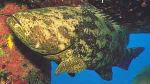
Huge Goliath Grouper, also called Jewfish, are abundant
on our reefs and are a protected species. Giant Goliath grouper also make many of the wrecks their home. Anglers should remember that grouper are extremely slow-growing fish and conservation of these species is critical. For current regulations, visit the Florida Fish and Wildlife Conservation Commission. There is much debate amongst the locals as to the necessity of this protection because when fishing the reefs, it is common, almost expected, to have a Jewfish steal your catch as you reel it in. This is a real problem because now you have a huge Jewfish on your line and it is very laborious and time consuming to reel this 200 plus pound fish in to release it. The first time you catch one you will think it is exciting, but when they steal your catch time after time, you will tire of this annoying fish. There is no way to avoid the Jewfish, they are everywhere, just be aware it can happen to you. Other species of wreck dwellers are Black, Gag, Warsaw, and Snowy Groupers.
Anchoring & Mooring Buoys

Around the state there are mooring fields containing buoys with pickup lines provided to boaters, anglers, and divers. Mooring buoys are provided to prevent damage to the coral reef caused by boat anchors. Mooring buoys are also used as an aid to navigation and used to indicate sites that are off limits. Anchoring on a natural reef is illegal according to the Florida's Coral Reef Protection Act. Anchors damage fragile coral that supports over 6,000 species of marine life.
If mooring buoys are available on a site then it is required you use them. All buoys are available on a first come, first serve basis and some areas have time limits on their use. If there are no buoys available at a site and you have a small boat, ask another boat to tie up to their boat. If you must anchor near a reef, always drop your anchor in the sand outside the reef, preferably down current of the reef you wish to fish.
Did You Know - It is OK to fishing from mooring buoys in FKNMS that are outside of SPA areas.
Fishing from a mooring buoy is allowed in areas throughout FKNMS, Miami-Dade County, Broward County and Palm Beach County. If we have confirmed the rules, we indicate on our GPS Reef Charts with colored buoys symbols whether it is Ok to fish or not, and we also have details on individual sites on our Reefs & Shipwrecks pages.
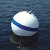 The Keys are all within the Florida Keys National Marine Sanctuary and located within the sanctuary are over 770 mooring buoys with 440 white with blue stripe buoys available to boaters. Anchoring on living coral is not allowed if the water depth is 40 feet or less or the bottom is visible, you must use mooring buoys. If no mooring buoy is available and you are outside a no-anchor zone you may anchor in sand. Buoys available for boats under 100 feet are 18" white balls with a blue stripes. Yellow 30" diameter buoys that have no pick-up lines mark areas where you are not allowed to anchor, fish, only pass thru. Spar buoys that are cylindrical, tall, and white with orange markings mark Wildlife Management Areas and sites on the Shipwreck Trail.
 ![]() FKNMS Buoys
FKNMS Buoys
Source: Broward County's Reef Saving Mooring Buoys brochure
Links to Mooring Buoys in Florida
- We indicate mooring buoy GPS numbers on our Reef Charts
 How to Use a Mooring Buoy Video by NOAA
 How to Use a Mooring Buoy - NOAA
 Mooring Buoy Rules in Biscayne National Park
 Biscayne Bay National Park
A message from Keith Mille, Environmental Specialist III Division of Marine Fisheries - Artificial Reef, Program Fish and Wildlife Conservation Commission:
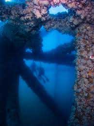 "Proper boating technique for working reefs obviously varies based on the type of vessel one is using, and careful evaluation of the weather and sea conditions. In my experience, captains have developed their own techniques unique to their vessel and style of fishing. While there is not necessarily any right or wrong way to fish a reef, I do see many many lost anchors on artificial reefs.
Anchoring on an artificial reef can probably be the most challenging, especially if the anchor becomes entangled. Some vessels have capsized as a result of improperly anchoring while fishing.
You may recall a few years ago the tragic loss of the football players off Anna Maria Island when they improperly tied the anchor to the stern during rough seas. FWC has a boating safety & education program you may want to mention. There are FWC and USCG Auxiliary courses captains may want to take, and of course there is no substitute for experience.
We encourage our readers to visit boating safety websites and encourage you to educate yourself for safe fishing, boating, and diving. Here's the USCG site USCG Boating. For SCUBA diving the Oriskany visit FWC's Oriskany page.
Trolling for Fish Above a Reef
Anglers should avoid trolling above natural and artificial reefs. You risk a hook-up to a structure and destroying your gear. Hooks can also injure and scar the living coral, leaving them vulnerable to infection by microscopic organisms that can kill the coral. And it is against the law to harm coral. Trolling along the sides of natural reefs or between reef ridges can be very rewarding.

Photo Courtesy of MBARA
Beware of Barracuda's when Spearfishing, they will come after your catch!
Spearfishing on Reefs and Shipwrecks
Spearfishing natural reefs, shipwrecks, and artificial reefs around Florida is a popular sport. Spearfishing "Is Allowed" in all counties around Florida EXCEPT Monroe County (Key Largo to Long Key Bridge). There are also special Marine Zones and many state parks where spearfishing is NOT Allowed. We detail Marine Zones below that have their own special rules. Again, always research the rules of the AREA you will be spearfishing before venturing out on our waters.
Visit our Fishing Regulations for Spearfishing for the State of Florida rules.
Visit Regulations for Spearfishing for Monroe County, Florida including the Florida Keys National Marine Sanctuary for federal rules.
Types of Reefs in Florida
 Natural Reefs
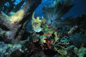
Natural Reefs and ledges flank the 120 miles of the Florida Keys, Key Biscayne, and half way up the Florida Atlantic Coast crating the third largest reef system in the world behind the Great Barrier Reef. Our coral reefs are created by a large variety of coral species, visit FWC's Photo Gallery of Coral Species for details. The most common reef-building corals are brain, star, elkhorn and staghorn. Along with the major barrier reef structure, there are patch reefs found scattered around the main reefs.
Florida's coral reefs provide habitat for a large variety of fish species. You can fish the shallow inshore patch reefs for Yellowtail Snapper, Mutton Snapper, Grey Snapper, a variety of Grouper, Hog Fish, Mackerel or Kingfish. Further out to depths of 150 feet are larger reef systems with reliefs of 40 plus feet with large caves, ledges, and natural holes providing breeding grounds and shelter for larger fish species.
Many natural reefs are within Federal and State special zones to protect the living reefs. See our section below Special Marine Zones for areas that have restrictions and their own regulations.
Shipwrecks & Artificial Reefs
 There are about 750 named shipwrecks spanning the entire Gulf of Mexico, Florida Straits, and the Atlantic waters of Florida. Shipwrecks are a popular fishing and diving destination. Shipwrecks include intentionally laid wrecks for Artificial Reefs along with ships that found their fate on Florida's sea floor. Wrecks are not only ships but include submarines, tanks, busses, airplanes, mixing trucks, cargo containers, train cars, or any other large vehicle that would make a good artificial reef. The information on the whereabouts of all shipwrecks in the US is free and available on the NOAA Office of Coast Survey's web site. We have GPS Coordinates to every documented shipwreck in Florida on our GPS Coordinates pages.
Shipwrecks and artificial reefs create a habitat for fish and anchor site for reefs to form. Many shipwrecks are covered in coral and hardly distinguishable beneath the living coral reefs that have formed on them. Because of the habitat they invite, fishing near shipwrecks can be rewarding, although may sites have restrictions.
Shipwrecks, like other historical and archaeological sites, are non-renewable resources. Although ships continue to sink, there will never be another wrecked Spanish galleon. Historic shipwrecks that exist today are all we will ever have. They represent limited and unique opportunities to learn about the people who built them and lived, sailed, and wrecked on them. All shipwrecks in Florida waters are protected under the Florida Historical Resources Act. This law protects all archaeological sites on state-owned or controlled lands and submerged bottomlands from unauthorized disturbance, excavation, or removal of artifacts. The wrecks of the 1733 Plate Fleet and other shipwrecks located within the Florida Keys National Marine Sanctuary also are protected by federal law, just as natural resources are protected, so that future generations may visit, learn from, and enjoy these unique examples of our maritime heritage.![]()
WARNING: Never disturb or remove artifacts from shipwrecks or reefs, it is against Florida state law. Fines for the removal of artifacts by excavation and removal of artifacts from state lands/waters can be hefty!
Shipwreck Trails
Centuries old shipping routes transverse through the Straits of Florida where there is a high concentration of shipwrecks called Shipwreck Trail and an abundance of artifacts that still remain undiscovered in this area. The Shipwreck Trail is within the FKNMS, visit their website for details on the 9 shipwrecks in this area. FKNMS's website has an underwater guide for each site on the Shipwreck Trail, providing the shipwreck and mooring buoy positions, history, a site map, and information about marine life inhabiting the wrecks. The deeper wrecks in 100 to 250 feet of water hold the larger, loner fish such as Amberjack, Wahoo, Grouper, and Kingfish. The shallower wrecks tend to hold a larger number of schooling fish such as Yellowtail Snapper, Mutton Snapper, and Grouper. Diving the shipwrecks is an exciting adventure but please leave your spear gun behind, there is no spear fishing allowed on theses shipwrecks nor in the state waters surrounding The Keys.
New for 2012 is the Florida Panhandle Shipwreck Trail which contains 12 exciting shipwrecks across three counties in northwest Florida. You can pickup a Passport at local dive shops and explore these wrecks either diving or fishing.
Artificial Reefs and Their Construction
Photo Courtesy of Florida Fish and Wildlife Conservation Commission
The majority of Florida's offshore reefs are man-made artificial reef constructed to create marine habitat for our aquatic residents and to provide recreational fishing and diving spots. The State of Florida and local counties are very proactive in creating artificial reefs around the state. In addition to increasing or enhancing habitat, artificial reefs improve commercial and recreational fishing and diving opportunities, provide socioeconomic benefits to local communities, minimize user conflicts, and facilitate reef research.
The vast sea floors of Florida, especially the Gulf side, are fine sands that shifts with the currents and storms. There are natural holes and ledges where you can find fish offshore, but the best fishing in on one of the established reefs, whether natural or artificial.
Once a new reef is placed, it doesn't take long for marine inhabitants to find the new reefs and call them home. Although the best reefs to fish are ones that have been established for several years. As marine organisms attach to the structure, fish arrive to feed on them, thus a community gets established. For a very educational demonstration view What Are Artificial Reefs by Reef Maker.
079_small.jpg)
Photo Courtesy of Florida Fish and Wildlife Conservation Commission
Florida Fish and Wildlife is in charge of overseeing the deployment of artificial reefs in Florida. Since the 1920's there have been over 2,400 artificial reefs placed along the 8,426 miles of tidal coastline in Florida, most of which have been deployed in the past 20 years. Funding for these reefs comes from many sources including grants. Reefs are very important to our tourist based economy providing habitat for fisheries which in turn provide recreation for anglers, boaters, divers, and snorkeling enthusiasts.
To learn about the process of creating an artificial reef read this document created by several agencies About Artificial Reef Management.
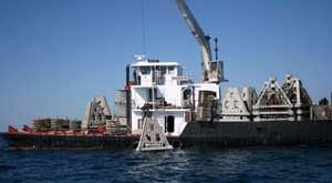
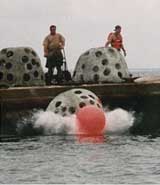
Most artificial reefs are are constructed of concrete balls, slabs, man-made reef triangles, concrete light poles, or materials that are heavy and will last for generations. An interesting material used for reefs on the Atlantic coast are Erojacks which are cement beach barriers that were used during WWII. Erojacks are five feet in diameter and resemble children's jacks. Old car tires filled with concrete were used for artificial reefs many years back and it has been decided they are not good reef-making materials as they move with strong storms.
MBARA deploying artificial reefs.
Many artificial reefs are actually ships, planes, box cars, or even school busses intentionally sunk to create marine environments for fishing and diving. If you are interested in how FWC creates artificial reefs, order the free VHS video "Creating Marine Habitat: The Artificial Reef" which focuses on the various materials used to create artificial reefs, how locations are selected for deployment, and the overall importance of artificial reefs. Another interesting read is available online "Guidelines for Marine Artificial Reef Materials", this large document is very interesting and detailed with lots of photo's.
FWC has sunk a number of ships to create artificial reefs including the most recent Gen. Hoyt S. Vanderberg in the Keys and the Oriskany near Pensacola Pass. As in many artificial reefs, divers & fisherman are reminded that conditions change over time as the structure is influenced by currents, scouring, and storm events. Additionally, steel artificial reef materials like ships will gradually experience structural changes as metal components naturally corrode in the marine environment.
In 2009 FWC sunk the Gen. Hoyt S. Vandenberg in the Keys at a total cost of $8.6M; watch this video on this amazing sinking. Visit FWC's website which is a treasure trove of information on our offshore reefs.
Reef Making and Monitoring Organizations
 There are many organizations around Florida that create, protect, and monitor our artificial reefs. Florida Go Fishing gives many thanks to these organizations for their hard work.
Not only does deploying artificial reefs benefit the marine fisheries by providing habitat but they also give divers and anglers great places to enjoy.
Visit the many Florida reef deploying organization's websites to learn more about reef development and conservation.
><((((?> We would also like to acknowledge Reefmaker Artificial Reefs for their dedication to the building of artificial reefs in Florida.
![]() There are special marine zones governed by Federal and State agencies throughout Florida. Before visiting any of the areas below please review their current regulations. Rules change frequently so we only provide guidance on this website; it is up to you to keep up to date on current regulations!
There are special marine zones governed by Federal and State agencies throughout Florida. Before visiting any of the areas below please review their current regulations. Rules change frequently so we only provide guidance on this website; it is up to you to keep up to date on current regulations!
Florida Keys National Marine Sanctuary (FKNMS)
Source: http://dhr.dos.state.fl.us/archaeology/underwater
/galleontrail/mapLarge.cfm Click Image to Enlarge
The Florida Keys National Marine Sanctuary (FKNMS) is North America's largest natural coral reef system and the third longest barrier reef in the world (following Australia and Belize). The sanctuary is comprised of 2,900 square nautical miles around the 120 mile long island chain of the Florida Keys which includes waters of Florida Bay, the Gulf of Mexico and the Atlantic Ocean. View the FKNMS Map which shows the Marine Zones through south Florida.
There are mooring buoys throughout the park, see our Anchoring & Mooring Buoys section above for links to their locations throughout The Keys. On our webpages for Reefs & Shipwrecks in The Keys we have details diagrams showing you which buoys you can fish from and which you cannot. Surprisingly, there are a lot you can fish from so don't let all the rules scare you; we make it easy to find great spots in The Keys.
Most activities of fishing like catching live bait or using fish chum are allowed in the sanctuary outside of marine zones but dispersing materials into the water to attract fish is not allowed and carries a hefty fine. Read this US Coast Guard Bulletin for details.
Special Rules for the Florida Keys National Marine Sanctuary (FKNMS)
The following reefs are protected by Marine Zones established by the FKNMS and most are marked with BIG YELLOW BUOYS:
| RO - Research Only Special-Use Areas: NO FISHING, No Entry Without a FKNMS Access Permit |
| ER - Ecological Reserves: NO FISHING,
Vessels may only Enter Area if they remain in Continuous transit with fishing gear stowed (diving and snorkeling are prohibited). FKNMS Access Permit required to stop or use a mooring buoy.
|
| SPA - Sanctuary Preservation Areas: NO FISHING,
Diving and Snorkeling allowed, mooring buoys available EMA - Existing Management Area within SPA - regulations differ by area, check rules before fishing
|
Reef Diagrams of Each Reef Site with Rules & GPS Coordinates |
Biscayne National Park
Biscayne National Park is just south of Miami and encompasses 172,000 acres of islands (Boca Chita Key, Elliott Key, and Adams Key), natural reefs, shipwrecks in the Maritime Heritage Trail, and the famous Stiltsville. 95% of this national park is covered in water, most of which is only accessible by boat. There are mooring buoys throughout the park that can be used on a first come, first serve basis for a 4 hour period, see our Anchoring & Mooring Buoys section above for links to their locations throughout Biscayne Park.
Fishing within the park is governed by Florida Fishing Rules and is allowed within the park. I am awaiting confirmation if you can fish from mooring buoys within the park, so enquire locally before you tie up and fish from a buoy here.
Visit the Biscayne National Park on the National Park's Service website to learn the history of this area and information on planning a trip here.
John Pennekamp Coral Reef State Park
A very popular destination is the John Pennekamp Coral Reef State Park located at Mile Marker 102.5 Overseas Highway. This park is the first undersea park in the United States and encompasses 70 nautical square miles. This state park offers full facilities with beaches, diving, snorkeling, camping, a boat ramp, picnic areas, hiking trails, boat rentals, and boat tours. Located between 3 and 8 miles offshore off the coast are beautiful natural coral reefs, shipwrecks, and the famous Christ of the Abyss, located inside Key Largo Dry Rocks. Christ of the Abyss is an 8 1/2-foot-tall (2.6 m) statue of Jesus Christ weighs 4,000 pounds (1,800 kg) and sits in nearly 25 feet (7.6 m) of water.
Fishing in John Pennekamp Coral Reef State Park is allowed only in designated areas.
Visit http://www.pennekamppark.com for more information. ![]() John Pennekamp Diagram
John Pennekamp Diagram ![]() Key Largo Dry Rocks Diagram
Key Largo Dry Rocks Diagram
Dry Tortugas Ecological Reserve
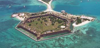
Source: http://www.nps.gov/drto/index.htm
The Dry Tortugas Ecological Reserves is located 70 miles west of Key West. This national park consists of seven keys (Garden, Loggerhead, Bush, Long, East, Hospital, and Middle) collectively known as the Dry Tortugas and is situated on the edge of the main shipping channel between the Gulf of Mexico, the western Caribbean, and the Atlantic Ocean. There are spectacular natural reefs, hard bottom areas, and numerous shipwrecks in this formerly busy shipping throughway.
There are 46 square miles of no-take no-anchor Resource Natural Area which is an ecological preserve. A Access Permit is required if you plan to stop your boat for any reason in this area. You can pass through this area in marked channels with all fishing gear stowed away. Visit our webpage The Keys Parks & Preserves for details on fishing and visiting the country's first underwater and most remote national park.
South Atlantic Fishery Management Council's MPA Zones
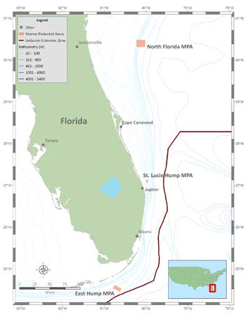
Source: http://www.safmc.net/MPAInformationPage/
tabid/469/Default.aspx - Click Image to Enlarge
The South Atlantic Fishery Management Council's MPA Areas are located in the deep waters of the Atlantic Ocean. The MPAs are designed to protect a portion of the long-lived, "deepwater" snapper grouper species such as Snowy Grouper, Speckled Hind, and Blueline Tilefish.
- In the following MPA areas located in Florida there is No fishing for or possession of any Snapper Grouper species.
- Trolling for pelagic species such as Tuna, Dolphin, Mackerel and Billfish is allowed within the MPAs.
- There are more rules for entering these areas if you are fishing so please read the regulations on SAFMC's webpage. We also have the brochure for easier understanding of the Regulations for Deepwater Marine Protected Areas in the South Atlantic.
- Federal regulations for Snapper and Grouper in the Atlantic.
Please check the links below before fishing in the deep waters offshore near Islamorada, Jupiter to Daytona, or Jacksonville and get the coordinates so you do not unintentionally fish these areas.
North Florida MPA is located 60 nautical miles off the mouth of the St. John's River near Jacksonville. Water depths in this MPA range from 197 to 656 feet with a deeper area up to 1,247 feet.
St. Lucie Hump MPA is located east of Jupiter 9 nautical miles southeast of St. Lucie Inlet. This is a very popular trolling area and is sandwiched between popular fishing reefs.
East Hump MPA is located near the popular fishing spot called the "Islamorada Hump" 13 miles southeast of Long Key, this deep water (636 to 971 feet deep) area has 500 foot high humps in a pinnacle-like formations.
Oculina Bank is a natural coral reef that runs from Fort Pierce to Daytona starting at 17 miles offshore and runs to the edge of the Atlantic Ocean's Continental Shelf.
FWC has made available to the public reef locations and we listed local reefs on this website along with various County's having their own list. Visit our Reef GPS Coordinates page to view our reef lists online and get your FREE printable copies of the GPS Coordinates.
Visit our Offshore Fishing page for tips on fishing our reefs.
DISCLAIMER: We provide a brief description of regulations for your convenience. This information is provided as a guide for Florida fishing & boating and is not conclusive. The absence of complete laws, rules and regulations in this summary does not relieve persons from compliance with those laws, rules or regulations. We encourage your to ALWAYS check local regulations before fishing. We will not be held liable for any damages if you rely on the regulations listed on this website.


