
Southwest Reefs & Shipwrecks
Locations > Southwest > Reefs & Shipwrecks
![]() GPS Coordinates Lee County
GPS Coordinates Lee County ![]() Lee County Beaches & Parks GPS File Downloads
Lee County Beaches & Parks GPS File Downloads ![]() PDF
PDF ![]() KML
KML ![]() GPX
GPX 
USCGC Mohawk (WPG-78)
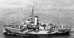 The 165'x36'x12' USCGC Mohawk, the "Mighty Mo", was built in 1934 with her home port of Cape May, New Jersey. She was commissioned to join forces in WWII to patrol the North Atlantic in the Greenland Patrol and performed 14 successful attacks on Nazi submarines. She was damaged twice, once an iceberg penetrated her side and the other her main deck receive a hit from a British aircraft that misidentified her. The Mohawk's most famous act was radioing General Dwight D. Eisenhower the day before the Normandy invasion to report the weather was clear and it was OK to proceed. Shortly after this broadcast she hit an iceberg. After the war she was sold and used as a pilot boat for over 30 years on the Delaware River. The new owners eventually lost her due to non payment of dockage fees on her Staten Island's berth. She eventually found herself in a scrap yard on Staten Island where she sat for 15 years rusting away. The Miami Dade Historical Maritime Museum eventually acquire the Mohawk and docked her in Key West. The museum did not have the funds to properly prepare her for visitors and decided to donate it to Lee County for use as an artificial reef. On May 16, 2012 she was towed to Fort Myers Beach and was prepared for the sinking. She was successfully sunk near Charlies Reef, sitting upright, 28 miles west of Sanibel Island in 90 feet of water July 2, 2012 using explosives.
Mohawk Reef Reports
July 2012 - One month after deployment a 20 foot Whale Shark arrives along with large schools of fish and marine growth has begun. A Blackfin Tuna was caught on the wreck along with large Cobia within the first month, amazing for such a new reef. ![]() Watch this Wink News Report
Watch this Wink News Report
September 2012 - 11 weeks after deployment a NewsPress photographer dives the Mohawk and records an amazing video of the abundant marine life that has already established themselves on the wreck. A week later the same photographer dove the wreck and encountered a Whale Shark! Both videos are testament to the benefits of deploying artificial reefs in Florida.
June 2013 - Mohawk becomes an Underwater Art Gallery - Austrian artist Andreas Franke photographed the Mohawk two weeks after it's sinking. He created beautiful photographs superimposed with images of people in period dress on the wreck underwater. Each photograph is encased inside steel framed Plexiglas panels with (5) 100-pound magnets attached to the back. Seventy-five divers and a photograher participated in installing the exhibit on the outside of the wreck. The panels will remain on the wreck for four months then removed and place in a museum. This video shows the panels, Franke, and the amazing amount of fish that now inhabit the wreck. This is surely a sight to see!
Misty Green-go
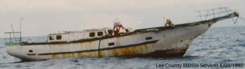
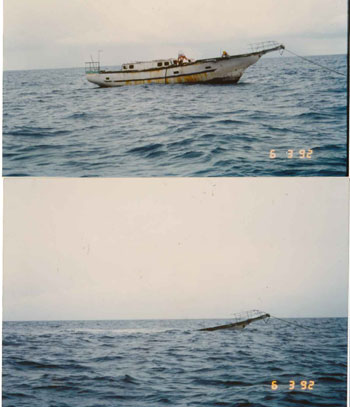 The Misty Green-go is a 50 foot boat from Nebraska built in 1979 by Ben Green, a 55 year old retired military man. It took Mr. Green 9 years to build his boat out of concrete and iron at a personal expense of $73,000 - $53,000 more than he expected and quite a large sum back in the 1970's. Misty Green-go's maiden voyage was on October 15, 1979 on the Missouri River with 1,000 onlookers, many sceptical if it would float.
![]() Spokane Daily Chronical Article "Concrete Boat Floats", October 16, 1979
Spokane Daily Chronical Article "Concrete Boat Floats", October 16, 1979
Mike Campbell of Lee County Marine Services tells us "the Misty Green-Go is not gone, just transformed to low relief rubble. It was a derelict vessel in Matanzas pass, the owner sold it to an entity hoping to use it for marine education; it soon became a money pit and then derelict. When the county removed it, it was identified as suitable reef material."
If anyone visits this site, please send us an update on it's condition.
![]() GPS Coordinates Collier County GPS File Downloads
GPS Coordinates Collier County GPS File Downloads ![]() PDF
PDF ![]() KML
KML ![]() GPX
GPX
Baja California 
The Baja California was a WWII 256 foot by 38 foot steel Honduran steamship built 1914. On route from New Orleans to Key West carrying tobacco, the Baja California was torpedoed by German submarine U-84 on 7/19/1942, and she sunk. Today she sits upright in 114 feet of water with 10 foot relief, 60 miles west of Naples. There are several resident Goliath Groupers who have made the Baja home along with thick schools of bait fish, snappers, amberjack and the other usual deep water suspects on the Gulf of Mexico. The GPS coordinates for the Baja California are all over the charts on the internet - our numbers were confirmed by a charter company, see below, that visits the site weekly on route to Key West.
If you would like to read a detailed story of the history of this site and what to expect when diving the Baja California visit http://wreckdiveguide.com/wreck-of-baja-california
Reef Reports
The Ultimate Getaway company in Ft Myers confirmed our reef GPS numbers, they visit the site weekly. On the stern of the wreck and there is an underwater tie off. The last two trips we have had Whale Sharks on the wreck. See http://www.ultimategetaway.net
Air Force Relay Towers
 |
| Click to Enlarge |
There are many Air Force Radio Relay Towers located in the southeast Gulf of Mexico that offer excellent action for Permit, Kingfish, Wahoo, Amberjack, Cobia and many other species. The towers are maintained by the Department of Defence have been out there since the war, some have beacons that still work, others are out of service. The towers were also used for bombing practice which has created many deep holes offering other areas to hold up fish.
The towers are teaming with marine life and are stopover spots for migrating species. Since most of the southwest Gulf is hard bottom with no structure, migrating fish are attracted to these towers as a stop over to feed on their way by. To fish the towers go upwind, up current and drift down to the tower. Use lots of chum and chunk baits to bring fish up from the bottom. Please note that you should not tie up to the towers, anchor in the nearby hard bottom.
R Tower
A trip to one of the towers takes planning, they are a good distance from any port and not near any other fishing spots, so be prepared. Check the weather, especially in the winter months, and double check the coordinates against your charts. You can travel over 100 miles round trip getting to a tower requiring a lot of fuel and time. The below videos give you a great idea what the sites have to offer in structure and fish.
L Tower
Reef Reports Collier County
Santa Lucia
August 2012 - Bryan Fluech of Florida Sea Grant along with Collier County and many other volunteers performed the annual cleanup of Santa Lucia removing over 500 pounds of cast nets, traps, anchors and other debris. Bryan also confirmed our chart numbers for the site.
Send us your reports on our Reef Reports page.
Multiple resources were used to create our Florida GPS Coordinates Reef Charts. This data is provided as a tool to increase your fishing and/or diving enjoyment and is not intended to be used for navigational purposes. This information is provided only as a courtesy and there are NO guaranties, warranties, express or implied, or representations as to the accuracy of this content. Florida Go Fishing assumes NO liability or responsibility for any errors or omissions in the information contained here AND is not responsible for location changes or inaccuracies of rules, bouys, hazards or markers. If you find an error or omission in the data, please feel free to contact us with the correct information and we will verify and correct it as soon as possible.


