Central East Reefs & Shipwrecks
Locations > Central East > Reefs & Shipwrecks
Brevard County
![]() Brevard County GPS Coordinates
Brevard County GPS Coordinates
Brevard County's offshore fishing offers some of the best bottom fishing in the state. The Gulf Stream takes a northeast turn just north of Port Canaveral creating an eddy of calmer currents. This area contains 3 large ridges that run north south to the coast offering fish a reprise from the strong Gulf Stream currents. In addition to the natural hard bottom of the ridges, the north end of the Oculina Bank is a little further east offering fish a huge, healthy reef system. With less fishing pressure and colder bottom temperatures than the southern counties, fish tend to be bigger and more abundant.
Kingfish are king in Brevard County with schools congregating close enough to the beach to actually see the schools! When they are running in this area you are guaranteed to land one, they are abundant here.
Did You Know? 1 Fathom = 6 Feet
Fathom Ridges and Natural Reefs
Heading east out of Port Canaveral you will encounter hard bottom ridges with relief from 2 to 14 feet, all running south to north parallel to the coast line until they curve to the northeast north of Canaveral. The ridges offer fantastic bottom fishing along with excellent trolling, especially when the King Fish or other pelagic species are running. Drift fishing is great as you will be taken with the current north running along the ridge lines.
12 Fathom Ridge - Depth 72', Relief 2'-12'
The first ridge has lots of corals and chunky bottom holding a variety of species. The southern part of this ridge line contains a high cliff with great relief.
21 Fathom Ridge - Depth 126', Relief 2'
This ridge is less defined with a broken rough bottom so fishing here is more suited to trolling than bottom fishing.
27 Fathom Ridge - Depth 162', Relief 2'-14'
The furthest ridge from port offers the most productive fishing experience, but not for the inexperienced angler. With a pronounced current and deeper water, getting your line down to the big fish takes the right gear. This ridge has lots of structure and eventually drops off to the east to over 200 feet. Fish tend to hold up on the west side of the ridges.
Oculina Bank MPA
Oculina Bank is located east of the 27 Fathom Ridge and is a federally protected marine zone. The only activity allowed in this area is trolling.
City of Vera Cruz
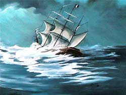
The 286 foot steamship City of Vera Cruz sunk during a violent storm in September 1880, with a loss of 68 crew members. Located just 17 miles from the coast, the City of Vera Cruz is a fantastic 75 foot dive and great fishing spot. Large fish inhabit the tall remains of this wooden hulled, metal reinforced structure and massive steam engine, some towering pieces reach over 30 feet from the sea floor.
 Laertes aka The Dutch Wreck
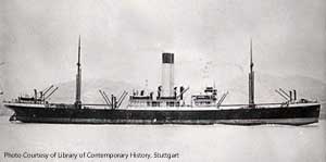
The 423 foot freighter Laertes was another 1942 WWII casualty, torpedoed by a German submarine U-109 on May 3rd, 13nm from shore, while on route to Bombay carrying war supplies including air craft, trucks and tanks. The wreckage today is scattered about the site in 70 feet of water and with a 30 foot relief, plenty of large fish have called this site home.
Pan Massachusetts
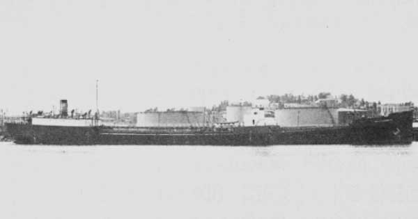
The tanker Pan Massachusetts was torpedoed and sunk during World War II by U-128 on 2/19/1942. The tanker was built in Bethlehem Steel Company, Alameda, CA in 1919 and she was 456x56x35 feet, 8202 tons with a steel hull. Today, she rests in 300 feet of water 40 miles east of Port Canaveral. The tanker was broken in 2 from the torpedo blast leaving a 300 foot bow section inverted, locally called the "Copper Wreck". The stern section is said to rest a few miles south. There is a strong 3.5kt current at this wreck, cold water temps, and visibility varies with the time of the year. The hull has a large jagged opening, home to many species of fish including Warsaw groupers. The hull is also covered with aquatic life including long stretches of Oculina coral running the length of it.
Image courtesy of the Mariners Museum, Newport News VA
St Lucie County
USS Muliphen
https://en.wikipedia.org/wiki/USS_Muliphen_(AKA-61)
Martin County
![]() GPS Coordinates Martin County GPS File Downloads
GPS Coordinates Martin County GPS File Downloads ![]() PDF
PDF ![]() KML
KML ![]() GPX
GPX 
 |
| Source: Historical Society of Martin County |
Georges Valentine 
Georges Valentine was a 767 ton steel hulled Italian Barque that sunk in a violent storm in 1904 100 yards offshore of Stuart. The ship was broken apart and it's cargo of mahogany lumber churned in the water, floating away with huge piles of lumber landing on the beach. The ship is broken into 5 prominent section in a 270' x 280' area and due to a constantly shifting sandy bottom, the structure is constantly changing-sometimes above the surface, some of it partially buried. Read the interesting tale of Georges Valentine's last voyage in brochure below. Florida Underwater Archaeological Preserve and US Nat. Register of Historic Places ![]() Brochure
Brochure ![]() Underwater Guide
Underwater Guide ![]() Museums In the Sea Underwater Tour
Museums In the Sea Underwater Tour
Here is a video off Jupiter showing Goliath groupers spawning. This video gives you an idea of the fish on local reefs and shipwrecks. Be sure to view this video full screen, it is amazing.
Multiple resources were used to create our Florida GPS Coordinates Reef Charts. This data is provided as a tool to increase your fishing and/or diving enjoyment and is not intended to be used for navigational purposes. This information is provided only as a courtesy and there are NO guaranties, warranties, express or implied, or representations as to the accuracy of this content. Florida Go Fishing assumes NO liability or responsibility for any errors or omissions in the information contained here AND is not responsible for location changes or inaccuracies of rules, buoys, hazards or markers. If you find an error or omission in the data, please feel free to contact us with the correct information and we will verify and correct it as soon as possible. .


