Central West Reefs & Shipwrecks
Locations > Central West > Reefs & Shipwrecks
Pinellas County
![]() GPS Coordinates Pinellas County GPS File Downloads
GPS Coordinates Pinellas County GPS File Downloads ![]() PDF
PDF ![]() KML
KML ![]() GPX
GPX
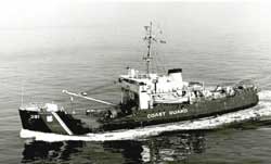
USCG Blackthorn

The 935 ton USCGC Blackthorn was built in 1943 at a cost of $876,403. Blackthorn was 180'x37'x12' with a maximum cruising speed of 13 knots powered by a single screw. In January 1980 the Blackthorn collided with the tanker Capricorn at the mouth of Tampa and sunk, killing 23 of her crew after the Capricorn's anchor dropped into the Blackthorn's hull. She was later towed out into the Gulf in 80 feet of water and sunk as Pinellas II artificial reef July 30, 1981. Today the Blackthorn is broken in two and covered in marine life with lots of fish to keep any angler happy. Off the stern of the Blackthorn is a barge and the Sheridan is 575 feet away.
![]() Blackthorn History Newspaper
Blackthorn History Newspaper ![]() Story of the Collision in Tampa Bay
Story of the Collision in Tampa Bay
![]() Site Diagram of Blackthorn, Sheridan & Seafood Barge
Site Diagram of Blackthorn, Sheridan & Seafood Barge ![]() Blackthorn Site Drawing
Blackthorn Site Drawing
The Sheridan
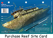
Twenty miles off Indian Rocks Beach you will find the rusting hulk of a 180 foot 383-ton tugboat, the Sheridan, which sunk in October 1988. She lies within the Pinellas #2 Artificial Reef Site about 575 feet from the Blackthorn and a barge, see links above for site diagrams. The Sheridan is a fantastic wreck dive. The 180-foot tugboat lies upright and fu lly intact in about 75-80 feet of water. The tug lists to starboard with its prop in place. The top of the wreck can be reached at 40 feet. The wreck is surrounded by concrete culverts and tires. Many consider the Sheridan to be one of the best wreck dives in the Tampa/Clearwater area. The Sheridan is home to several Goliath Grouper and barracuda and always has lots of marine life to observe. Spanish mackerel, amberjack, crevalle jack, trigger fish, snapper, and even the occasional shark frequent the reef site. This is a great spot to take pictures of some large grouper. Advanced wreck divers will enjoy exploring the open compartments. See movie below.
Gulfport aka Clearwater Wreck
The 164'x40' dredge Gulfport was build in 1913 by the Endicott Machine Corp in Baltimore, MD. She working in Florida in the 1930's on the expansion of the Okeechobee and Chokoloskee drainage project. Today she is broken up but contains lots of marine life worthy of a dive or fishing trip.
This well made video features the Gulfport and the Sheridan.
>
To see some excellent images of Pinellas County Reefs, visit their Flickr Artificial Reef Gallery.
Manatee County
![]() GPS Coordinates Manatee County GPS File Downloads
GPS Coordinates Manatee County GPS File Downloads ![]() PDF
PDF ![]() KML
KML ![]() GPX
GPX
Regina 
The 247'x36'x14' Tanker Barge Regina sank in a storm March 5, 1940 offshore of Bradenton Beach at coordinates 27 28.135 ' N and 82 42.139' W. Regina was carrying 300,000 gallons of molasses from Havana to New Orleans. The Regina was built in 1904 in Ireland as a single propeller, triple expansion steam engine and she also was rigged as a schooner for auxiliary power. Regina was converted to a tanker-barge and carrying molasses when she sunk in a storm in 1940. The site is 75 yards off the beach in 12 to 20 feet of water rising several feet off the sea floor, with the bow facing north. This site is frequented by divers and snorkelers because of it's easy shore access. Rich in sea life, the ship itself is broken with most of it's structure submerged in the sand. Flounder gigging is excellent at this site in the winter months. The site is located directly offshore from the dive shop on 7th Street N. in Bradenton Beach. There is no parking lot so you must drop your gear then find parking. If you arrive by water be aware of divers and snorkelers in the water from the site to shore and avoid this area completely is our best advice. ![]() Regina Brochure & Site Diagram
Regina Brochure & Site Diagram ![]() Detailed History of Regina
Detailed History of Regina ![]() Museums in the Sea
Museums in the Sea
Nohab (South Jack Wreck)
 |
 |
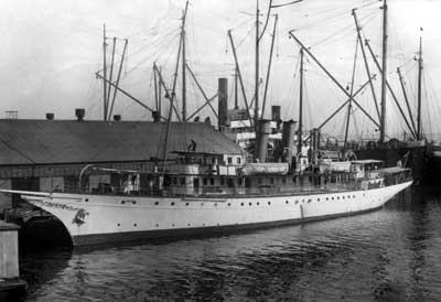
| Nohab at port in 1925 Romer, G. W.(Gleason Waite), 1887-1971. State Archives of Florida, Florida Memory |
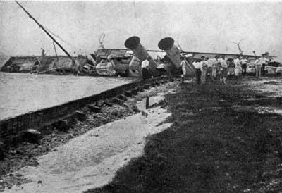
Nohab sinks in Miami 1926 State Archives of Florida, Florida Memory |
The 142'x23' steel Nohab was built in 1901 in Germany as a luxury pleasure ship named Lensahn III. During a hurricane in 1926 Nohab capsized and sunk in Biscayne Bay. In 1928 she was towed to Tampa by a California businessman, and she sunk again. Tampa authorities ordered her raised in 1934 so she was towed out to 66 feet in the Gulf and sunk again.
Resting 15 Nm off Egmont Key, Nohab's collapsed and flattened remains are scattered over a 150'x50' area with the engines, boiler and twin shafts remaining. This site is popular for amberjack fishing hence it's nickname South Jack Wreck. The Nohab has a colorful history and some very important historical figures enjoyed her during her heyday. ![]() Detailed History of Nohab
Detailed History of Nohab
Fin Barge
Fin Barge is located in 85 feet of water about 25 miles off Long Boat Pass. Fin Barge gets it's name from the two fin-shaped keels near the stern. The bow section has an open door where divers can peak inside the 300' wreck that rests upside down. It has been reported there is a large population of Goliath groupers on this wreck making spearfishing a challenge.
Doc's Barge
Nobody knows the origin of Doc's Barge but it's a great place to fish, spearfish and dive, always loaded with clouds of bait fish, kingfish, amberjacks, snappers and grouper. Resting upside down in 60 feet of water, 18 miles out of Long Boat Pass, the hull is broken in the middle and the structure forms great cover for large fish and fun swim throughs for divers.
Mexican Pride
The 200 foot Mexican Pride bulk cargo ship transported phosphate out of Tampa Bay up until the 1970 when she was subject to neglect. She was towed offshore about 35 miles and with one explosive to her bow, she sunk in 130 feet of water. Today she is broken in half and her structure is covered in marine life. A large group of resident Goliath groupers inhabit her structure and many spearfishing anglers report they can be aggressive. Anglers will be rewarded with large schools of huge amberjack and cobia to name a few.
Sarasota County
![]() GPS Coordinates Sarasota County GPS File Downloads
GPS Coordinates Sarasota County GPS File Downloads ![]() PDF
PDF ![]() KML
KML ![]() GPX
GPX
Natural Ledges, Rocks & Hard Bottom
Sarasota has a large expanse of hard bottom offshore. To find the hard bottom head towards the artificial reefs. Artificial reefs are intentionally placed near hard bottom areas. Rock outcropping can be found both inshore and offshore in Sarasota County, caution should be used in shallow areas as some are close to the surface. Using your sounder over your GPS is the best way to find great hard bottom and ledges in this area. The areas that are not public numbers tend to have the biggest fish. Another tip from Sarasota anglers is when your scouting for hard bottom or ledges look out for turtles or bait schools which tend to congregate over hard bottom. This video shows an area called Icebox which is typical of Sarasota's ledges.
Lynn Silvertooth
Lynn Silvertooth is a large (about a 1/4 mile square) artificial reef site only 2 miles from New Pass. This site has had dozens of deployments over the past decade and will continue with enhancements in the future. The old Ringling Bridge rubble, concrete reef balls, boxes and piles make up the bulk of the site that averages 25 feet with 5 foot relief. There are also memorial reef balls placed at this site which are the ashes of deceased mixed with concrete and formed into artificial reef balls. Since the site is so large, anglers do not feel crowded and can enjoy a fun fishing day for the large variety of species that inhabit this area. This site is marked Fish Haven on the NOAA charts, so you know it's a great fishing spot.
Bay Ronto
Bay Ronto was a 6,045 ton British freighter built in 1905 as Tronto. This 400'x52' freighter had a by a 495 nhp triple expansion engine. The Bay Ronto sunk in the heavy seas caused by a hurricane on September 13, 1919. The ship now lies upside down in 110 feet of water 30 miles SW of Venice. There is a large crack in her hull making the stern side 20 feet higher than the bow section. There are lots of compartments for experienced divers and spearfishing divers to explore and fishing this large wreck is excellent.
Antonio Ensenat
On Nov 1, 1943 at 3:00 am the Cuban schooner Antonio Ensenat collided bow to bow with the Honduran schooner Charta 10 miles southwest of Sarasota. Charta was on route from Tampa to Havana with its cargo of potatoes; Antonio Ensenat heading for Tampa from Havana with its cargo of Cuban rum. The bow seam of Antonio Ensenat split from the collision, sinking the ship in a mere 10 minutes. Half of the 300 barrels of Cuban rum cargo of the Antonio Ensenat tumbled overboard into the Gulf from the impact of the crash. The newspaper reported the accident was unavoidable, neither ship knew the other was there because neither had lights on due to the WWII coastal blackout regulation. Source: Sarasota Herald Tribune newspaper story "150 Barrels Cuban Rum Fall in Gulf" (reading this article and the rest of this 1943 newspaper is fascinating!)
Today, the Antonio Ensenat is mostly buried in the sand in 60 feet of water. About 20'x1' of hull protrudes from the sand, so this site is not a diving destination. Since this ship is buried in soft sand, the possibility exists that a major hurricane could expose large sections of the ship.
Multiple resources were used to create our Florida GPS Coordinates Reef Charts. This data is provided as a tool to increase your fishing and/or diving enjoyment and is not intended to be used for navigational purposes. This information is provided only as a courtesy and there are NO guaranties, warranties, express or implied, or representations as to the accuracy of this content. Florida Go Fishing assumes NO liability or responsibility for any errors or omissions in the information contained here AND is not responsible for location changes or inaccuracies of rules, bouys, hazards or markers. If you find an error or omission in the data, please feel free to contact us with the correct information and we will verify and correct it as soon as possible.


