
Lower Keys Reefs & Shipwrecks
Locations >The Keys > Lower Keys Reefs & Shipwrecks
![]() Middle
Middle![]() Upper
Upper ![]() GPS Coordinates
GPS Coordinates ![]() Maps of The Florida Keys GPS File Downloads
Maps of The Florida Keys GPS File Downloads ![]() PDF
PDF ![]() KML
KML ![]() GPX
GPX
 |
| Divers on old "Shipwreck" off Key West.in 1984 McDonald, Dale M., 1949-2007. Florida Memory |
Bahia Honda to Dry Tortugas from Longitude -81 09
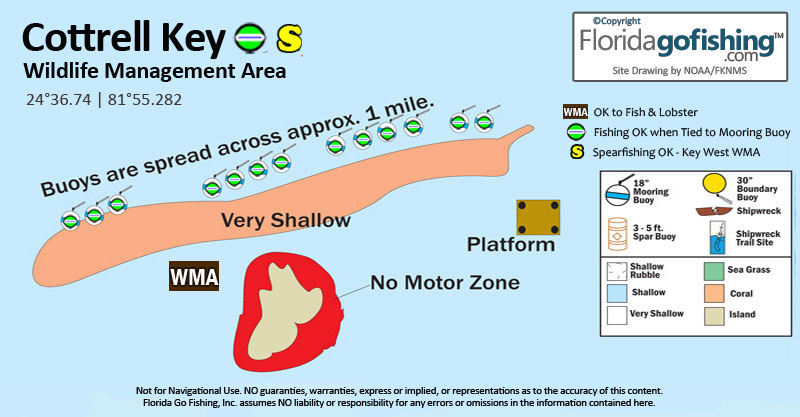
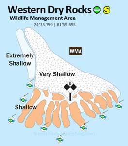
Shipwrecks, reefs, and wrecks in The Lower Florida Keys are some of the best the Keys has to offer. The Bayside of the Lower Keys is mostly within Wildlife Management Areas (WMA) where spearfishing is not allowed. There are also many No-Motor, No-Entry zones established for preservation and these areas are clearly marked with buoys. The Atlantic side have some amazing shipwrecks, natural reefs, and preservation areas for diving. The islands west of Key West are within the Key West WMA which does allow spearfishing. These islands are in very shallow clear waters and offer the best of the best fishing grounds in the Florida Keys.
FKNMS provides mooring buoys at popular fishing and dive sites to prevent anchor damage to reefs. If mooring buoys are at a site, you must use them. If none are available, find another boat to tie up to, and if you have no luck, you are allowed to only anchor in the sand away from the reef. Mooring buoys may be designated "fishing" buoys or "dive boat" buoys so please follow these on site rules.
We have done the research for you and indicate on the below charts where you can and cannot fish, lobster and spearfish. Most sites where you can hook & line fish you can lobster - if Lobstering is not allowed we indicate it. Lobstering on artificial reefs is not allowed in State waters so do not do it! The inshore waters are patrolled by many authorities and fines are huge. ![]() Lobstering Brochure
Lobstering Brochure
![]() = Mooring Buoy(s) - OK to fish when tied to buoy
= Mooring Buoy(s) - OK to fish when tied to buoy ![]() = Mooring Buoy(s) - No Fishing when tied to buoy
= Mooring Buoy(s) - No Fishing when tied to buoy
![]() Spearfishing OK at this site
Spearfishing OK at this site
![]() = No Spearfishing
= No Spearfishing ![]() Symbol Index - Click Diagrams to Enlarge
Symbol Index - Click Diagrams to Enlarge
New! Buy our handy PDF file loaded with 78 Florida Keys diagrams
|
Upper Harbor Key is a mangrove island surrounded by flats and is accessible at high tide. |
|
|
West Content Keys are accessible at high tides. |
|
 Looe Key Sanctuary Preservation Area (SPA) is a 5.32 sq nautical mile area, 25' water depth, located near Big Pine Key, about 5.5 nautical miles south of Ramrod Key and about 8 nautical miles southwest of Bahia Honda State Park. Looe Key was named for the wreck of the 1706 46-Gun 124'x36' British Frigate H.M.S. Loo, which ran aground February 5, 1744. Little remains of this wreck today. A clerk's error in listing the ship as "HMS Looe" is how Looe Key received it's name. No Spearfishing in EMA area. |
 |
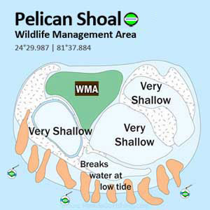 Pelican Shoal is located 6 miles southeast of Boca Chica. Rrecent hurricanes have washed away most of the island. A no-access buffer zone out to 50 meters from shore is in effect between April 1 and August 31 and the shoal area is closed by FWC. |
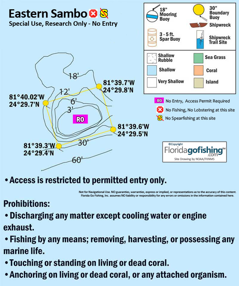 Eastern Sambo Research Only Area is a spur-and-groove bank reef with healthy coral formations. It is closed to entry and clearly identified by 30-inch round yellow buoys clearly marked with "Research Only." No Entry without a permit. |
 |
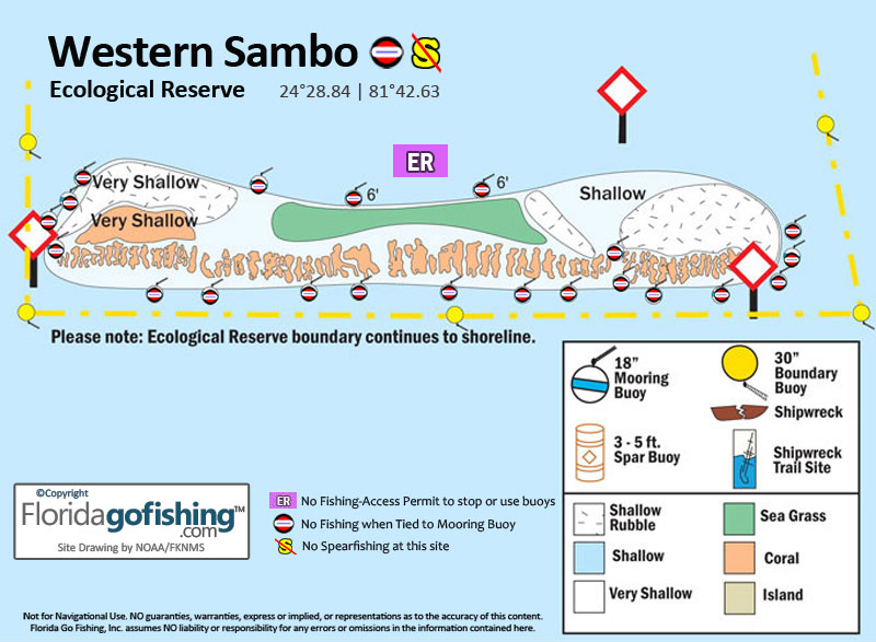
Western Sambo Ecological Reserve is 9 sq. nautical miles extending from the reef to the shore of Boca Chica/Naval Air Station Key West. Diving and snorkeling are allowed here but NO fishing or lobstering. |
|
OK to spearfish at this site located in state waters. |
|
|
|
The Harbor Keys are mangrove Islands 9 miles northeast of Key West. |
|
Sawyer Keys are 22 miles northeast of Key West, east of Johnston Key Channel and has shallow, tidal creeks running between them. |
|
|
Snipe Keys are a group of islands 16 miles northeast of Key West, due east of Mud Keys. |
The Mud Keys are mostly red mangrove islands 15 miles northeast of Key West and are dissected by navigable creeks. |
|
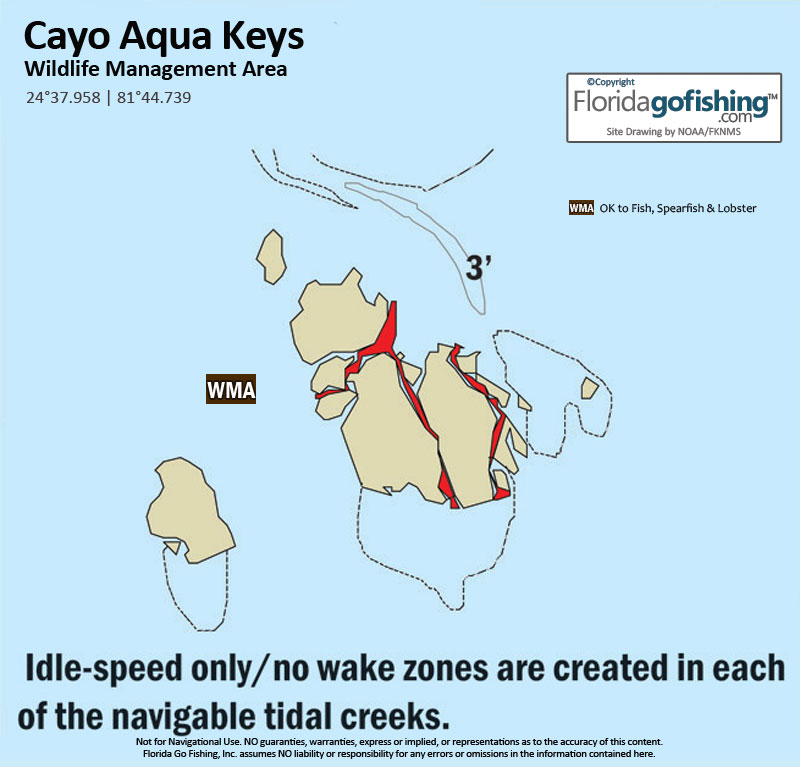
Cayo Agua Keys are a group of mangrove islands with tidal creeks between them, 6 miles northeast of Key West. |
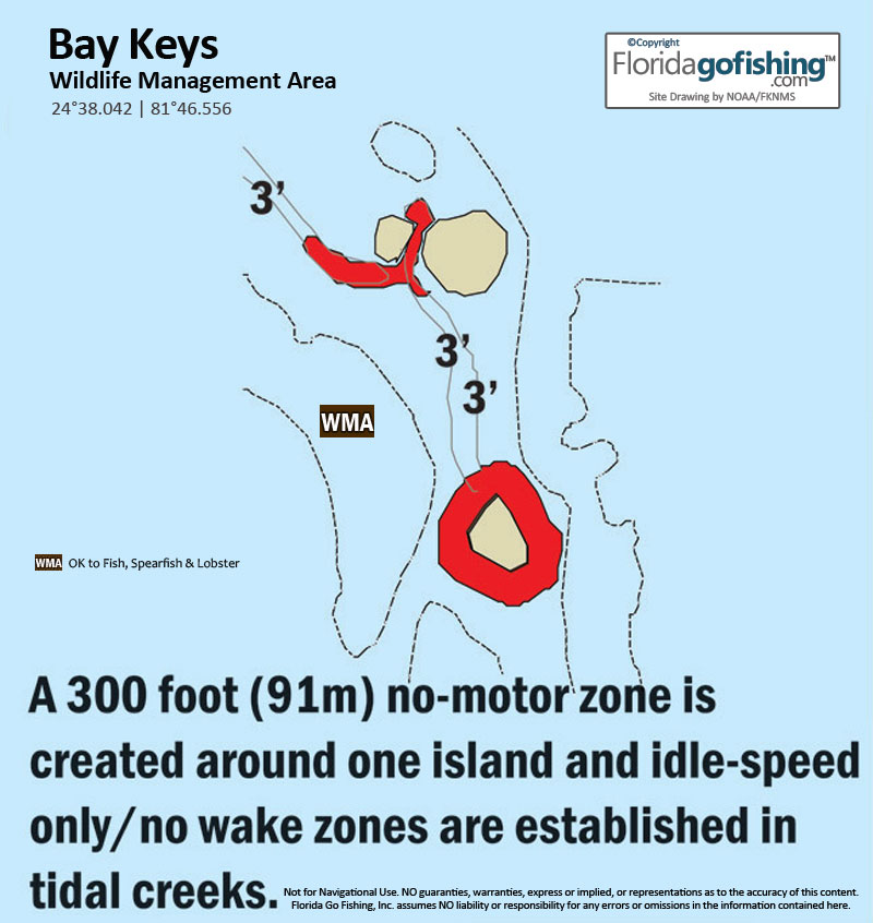
Bay Keys are a group of mangrove islands 4 miles north of Key West. |
 |
|
 |
|
|
Often crowded due to the beautiful beaches here, this area has some of the best fishing in the Keys. Be sure to obey the beach closure and no motor zones around these islands. |
|
|
|
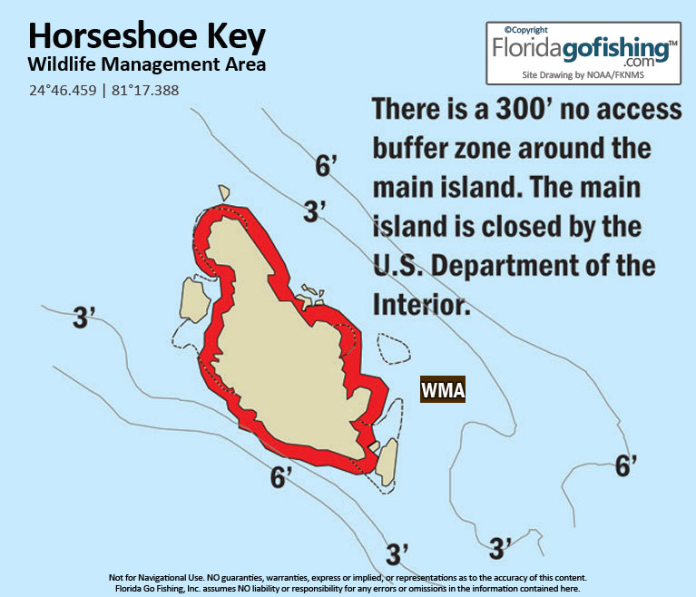
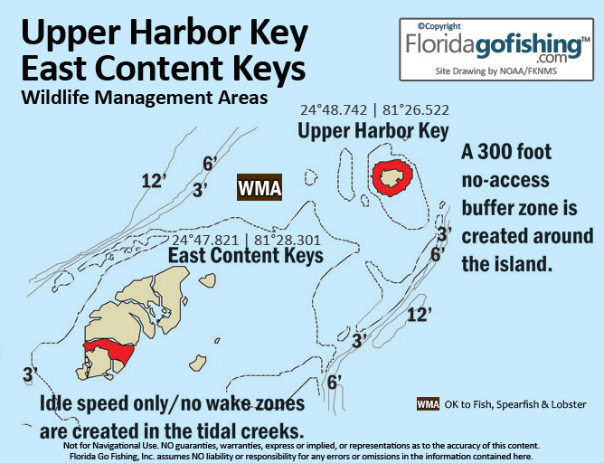


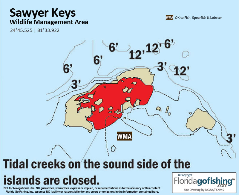
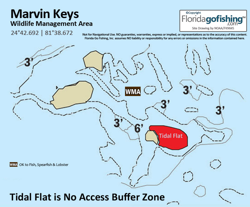
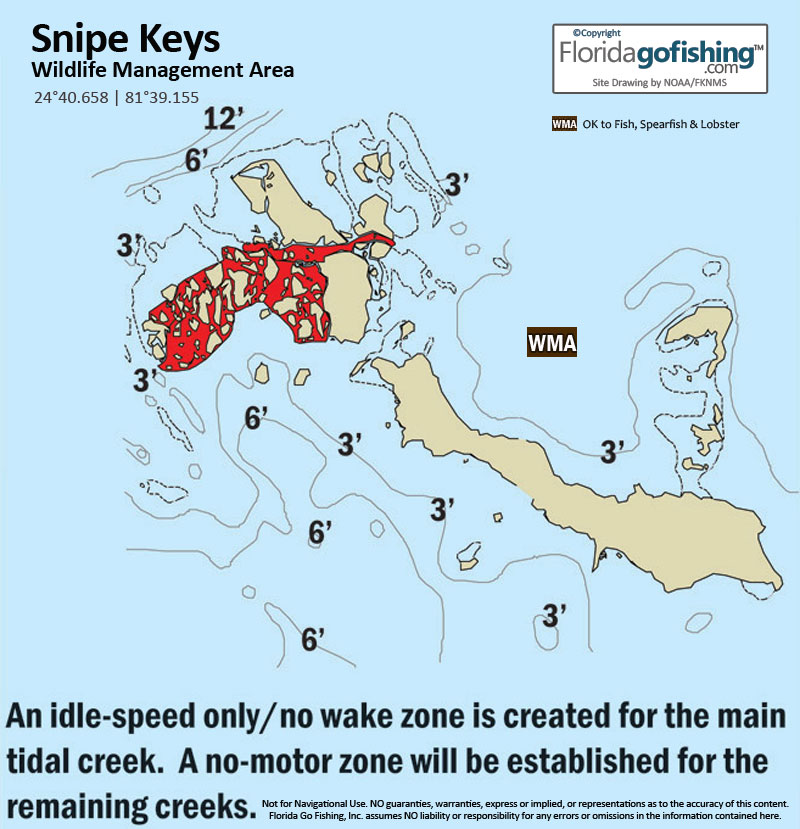
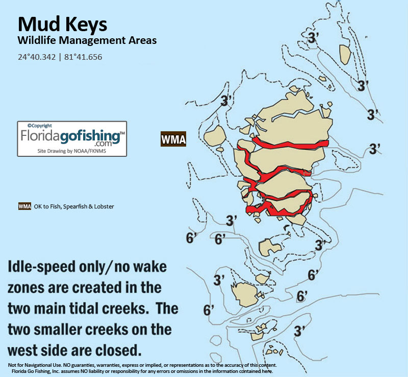


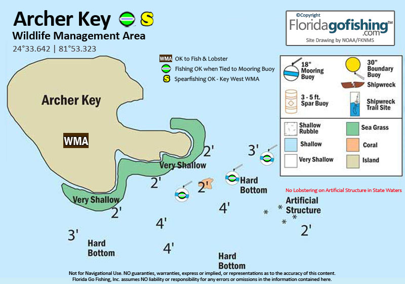


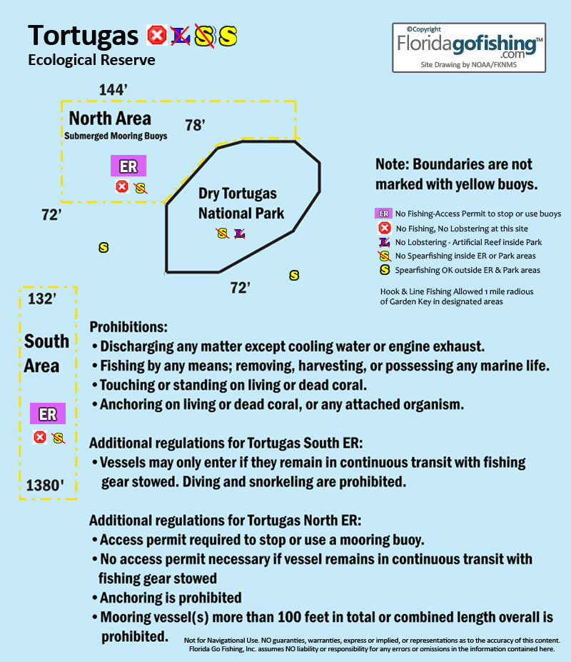
The above diagrams are courtesy of FKNMS. Florida Go Fishing created helpful icons and added site details to each diagram with rules.
Spearfishing
Spearfishing is allowed in state & federal waters south (west) of the Long Key Bridge. We indicate on our site diagrams where spearfishing IS allowed. Remember, it's irresponsible to spearfish anytime recreational divers are present, so use good judgement when hunting. After spearfishing, if you will be traveling through any no-take zones (SPA's, EMA's, ER's, ROA's, state and national parks) you must remain in continuous transit (do not stop) when returning to port with gear broken down and stowed away.
There is no spearing in State Parks. There are 2 Wildlife Refuge's in the lower Keys, the Key West WMA and the Great White Heron WMA, both allow spearfishing and lobstering. For more details visit our Keys Parks & Preserves page.
![]() FWC's Spearfishing Regulations for rules & species restrictions and
FWC's Spearfishing Regulations for rules & species restrictions and ![]() Spearfishing Regulations in Monroe County
Spearfishing Regulations in Monroe County
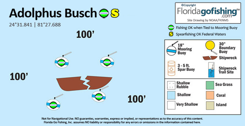
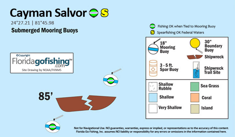
Cayman Salvage Master - OK to fish when tied to buoy")

 The Cayman Salvage Master lies one mile southwest of the Nine-Foot Stake. This 186-foot steel-hulled buoy tender was built in 1937 for the Coast Guard and was later used as a cable layer. She transported Cuban refugees during the Mariel boat lift in 1979, resulting inhere seizure by the US government. After being seized, she was sitting at the dock awaiting her fate when she sank unexpectedly. In 1985, she was raised and prepared to be sunk again as an artificial reef in 300 feet of water. But while being towed out for re-sinking, she prematurely sunk in just 90 feet of water where she currently resides. She settled on her side but was righted a few months later in 1985 by Hurricane Kate. In preparation for her scheduled sinking, the Cayman Salvage had been cleaned and stripped to create a smoother structure to foster pelagic life. Because of the removal of restricting parts, penetration is possible but is considered dangerous. It is recommended that divers who desire to pursue such a mission do so during a return dive and not on the first exploration. Bar jacks and schools of silversides frequent this site. Divers have reported that a 200-pound jewfish and a six-foot green moray eel call this vessel home. Note that dangerous aspects of this location are strong currents and the depth. A careful diver will find this artificial reef a great chance for exploration and a unique dive.
 ![]() Caymen Salvor Site Diagram
Caymen Salvor Site Diagram
Joe's Tug
 Joe's Tug in fact, is an old steel hulled shrimper originally destined as an artificial reef off the coast of Miami. She first sank at the pier in Key West in 1986. It was raised and cleaned in preparation for her planned sinking as an artificial reef in Miami. However, late on the night before it was scheduled to be towed north, a group of locals secretly towed the boat out of Key West harbor. The vessel sank in route to wherever they were headed, landing on the reef in about 65 feet of water. Some say a rum-soaked local pirate did it! Joe's Tug which is 75" in length now sits in about 65 feet of water in the sand, no longer intact. In 1998, Hurricane Georges picked up the wreck and tore her in half. The bow and stern now lie about 30 feet apart, and the wheelhouse has largely disintegrated over the years. The hull is easily accessible and is usually filled with schooling fish. She sits up right on the ocean floor surrounded by soft and hard coral formations and large sponges. This wreck is home to some very friendly moray eels and inquisitive fish. Joe's Tug is an easy and rewarding dive for both beginners and experienced divers. Open access to the wheel house and aft deck make this an enjoyable dive. Visibility is usually good due to its location outside of the reef and offers a great photographic location with a wide variety of corals and marine life. Also home to Joe's Tug is the famous Jewfish named "Elvis". Be sure to look for him so that when you go back home after your dive trip, you can tell your friends you actually saw Elvis in Key West!
Western Sambo  - No Fishing when tied to buoy")

 The Sambo Reefs is a collection of several reefs close to Key West. The area is divided into an Eastern area, a Middle area, and a Western area. The areas are located about four miles south of the Boca Chica Channel. If you go out to the Sambo Reefs, a pole will mark the eastern end of the reefs. This area is used for commercial and recreational diving but it is also used frequently for research purposes there is a Sanctuary Preservation Area marked by orange floats where research is done and fishing and taking lobster are prohibited. However, the rest of the area is great for taking lobster and shelling, especially in the inland grass bed located in shallower water. The Sambos reef line is known for its diverse sea life. The entire area ranges in depth from 10 to 40 feet. One popular spot on the west end of the Western Sambo is 25 feet deep and is frequented by divers. This section offers fields of branching coral that extend in all directions. Around the same area but heading down to 40 feet, a diver can see the heads of many corals abundant with sea life. This site can be seen for about 125 yards. This location is great for a variety of different dives at varying depths. However, if you are in search of collecting shells or other keepsakes, be careful which part of the area you are disturbing. The Sambos offer a variety of diving options and extensive amounts of sea life. The shallow reefs have strands of Elkhorn and stag-horn and tropical fish life is abundant.
 ![]() Western Sambo Site Diagram
Western Sambo Site Diagram
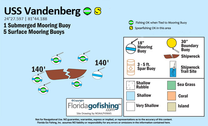
Vandenberg
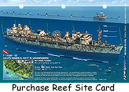


The 523 foot Vandenberg was sunk to become the largest artificial reef in the FKNMS and the second largest in the world. The ship settled upright on her keel in 1 minute 44 seconds, exactly as predicted by the many model tests performed to design the sink plan. Marine life began colonizing immediately and the ship is now home to pelagic and reef fish, and many other species of marine plants and animals.
On 22 February, 1943 General G. O. Squier Class Transport Laid down as a Maritime Commission type (C4-S-A1) hull, under a Maritime Commission contract, at Kaiser Co. Inc., Yard No. 3, Richmond, CA. On 15 July, 1961 The Ship withdrawn from the Reserve Fleet and transferred to the US Air Force and was converted to a Missile Range Instrumentation Ship and renamed General Hoyt S. Vandenberg.
In 1998 the ship was the stage for the science fiction movie "Virus", then in 2008 she was auctioned off and purchased for an artificial reef off Key West. In June 2012, artist Andreas Franke opened a very interesting exhibit at the Washington Ronald Reagan Building called "Vandenberg: Life Below the Surface" that showed images of the ship with people superimposed inside.
Today the Vandenberg is considered a safe, enjoyable dive for all experience levels of certified divers, those trained and experienced in light-wreck penetration are enjoying exploring the ship's many cargo holds, stair towers, elevator shafts and hallways. At 100 plus feet, holes cut along the outside of the hull purposed to sink the ship now provide swim-through opportunities for advanced and skilled technical divers.
![]() Vandenberg Site Diagram
Vandenberg Site Diagram
Radio Towers
 |
| Click to Enlarge |
The southeastern Gulf of Mexico has numerous Department of Defence Radio Towers that offer excellent fishing, especially for migratory species. Popular towers are located north of Key West. For more information on the radio tower's locations and tips for fishing them visit our Southwest Reefs & Shipwrecks page.
Reef Reports Lower Keys
August 2012 - Lobstering off Key West
Mexico Beach Artificial Reef Assoc went Lobstering and caught around 25 lobsters for the week and reports: I wanted to let you know that your web site helped me locate some lobsters in Key West this past week. I really loved the info on no-take zones, etc. Some of the numbers you had on your site for Key West were very nice for diving, and we found a few lobsters there. However, we quickly found that we had to get away from the nice dive sites and dive places most divers wouldn't be interested in to come close to getting our limit. I had a little excitement on the last day when I released an undersized lobster and it was immediately attacked by a hammerhead shark. I didn't see the shark until it swooped in from behind me, attacked the lobster, and then carried it off. It made me wonder if it had been following me and my lobster bag around waiting for an opportunity. It startled me but I wasn't really scared because I could tell it was only interested in the lobster.
Send us your reports on our Reef Reports page.
![]() Middle
Middle![]() Upper
Upper ![]() Symbol Index
Symbol Index ![]() GPS Coordinates
GPS Coordinates ![]() Maps of The Florida Keys
Maps of The Florida Keys
Multiple resources were used to create our Florida GPS Coordinates Reef Charts. This data is provided as a tool to increase your fishing and/or diving enjoyment and is not intended to be used for navigational purposes. This information is provided only as a courtesy and there are NO guaranties, warranties, express or implied, or representations as to the accuracy of this content. Florida Go Fishing assumes NO liability or responsibility for any errors or omissions in the information contained here AND is not responsible for location changes or inaccuracies of rules, bouys, hazards or markers. If you find an error or omission in the data, please feel free to contact us with the correct information and we will verify and correct it as soon as possible.


