
Collier County GPS Numbers
GPS Coordinates > Southwest > Collier
 Collier County in Southwest Florida is a year round destination for anglers and divers alike. The shallow, sandy bottom requires having reef GPS numbers in order to find fish. It is said that after 10 miles, reef depths only increase 1 foot per mile and reefs are far and few. When you do arrive at a reef or shipwreck, you will be pleasantly surprised at the abundance of fish species present. Collier County from North Naples south to Marco Island and the 10,000 islands has numerous artificial reefs deployed that are well established and full of fish! Popular ports to access offshore reefs in
Naples are
Wiggins Pass, Doctors Pass, Naples Bay, Isles of Capri, Marco Island, Goodland, Port of the Islands, Everglades City, Chokoloskee and 10,000 Islands. If you are venturing out of Marco Island you may want to look at reefs in neighboring Monroe County for locations near Cape Sable. Lee County is a short distance north offering a large variety of sites to easily explore.
Collier County in Southwest Florida is a year round destination for anglers and divers alike. The shallow, sandy bottom requires having reef GPS numbers in order to find fish. It is said that after 10 miles, reef depths only increase 1 foot per mile and reefs are far and few. When you do arrive at a reef or shipwreck, you will be pleasantly surprised at the abundance of fish species present. Collier County from North Naples south to Marco Island and the 10,000 islands has numerous artificial reefs deployed that are well established and full of fish! Popular ports to access offshore reefs in
Naples are
Wiggins Pass, Doctors Pass, Naples Bay, Isles of Capri, Marco Island, Goodland, Port of the Islands, Everglades City, Chokoloskee and 10,000 Islands. If you are venturing out of Marco Island you may want to look at reefs in neighboring Monroe County for locations near Cape Sable. Lee County is a short distance north offering a large variety of sites to easily explore. ![]() Southwest Reefs & Shipwrecks
Southwest Reefs & Shipwrecks
GPS Numbers File Downloads
![]() PDF
PDF ![]() KML
KML ![]() GPX
GPX
NOTE: 29 Pyramids deployed in 2015 are not on this list but are include in files for sale.
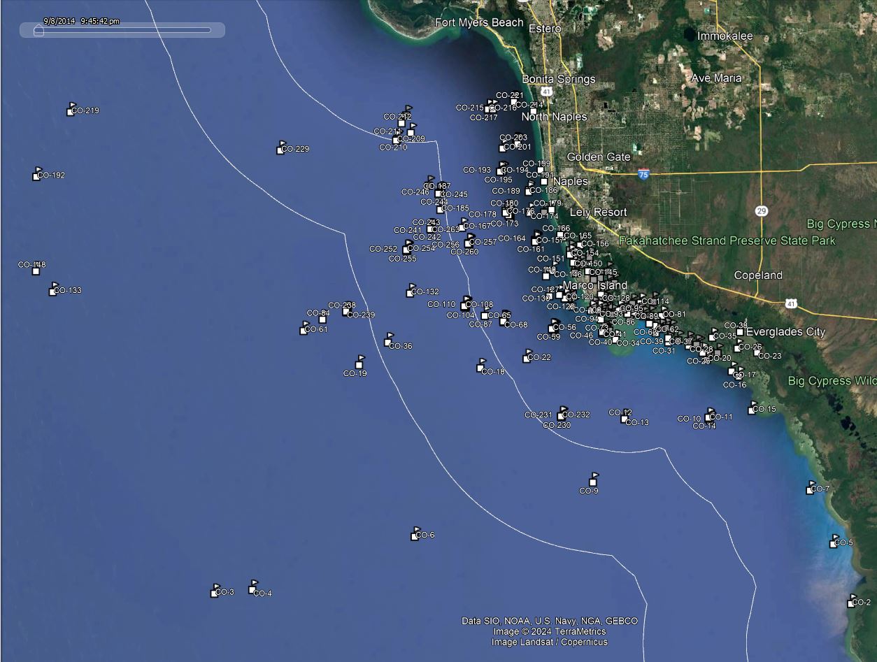
Click the Fishing & Dive Sites memory card image above to purchase Collier County reef sites on a chip. The map below shows the reef site locations included and how they will look on your GPS unit. The site names, materials and rules are located inside the waypoint's description field. Visit Waypoints on GPS Units for more information.
| Site ID / Reef Name | Material |
|---|---|
| CO-1 HM Bickford | 503 ton Schooner West of Cape Sable mid Gulf |
| CO-2 Shark River | Lit Marker GPS Waypoint |
| CO-3 Baja California | 256'x38' Steel Honduran Steamship built 1914 |
| CO-4 Tower L | Air Force Relay Tower |
| CO-5 Highland Beach | Lit Marker GPS Waypoint |
| CO-6 Tower T | Air Force Relay Tower |
| CO-7 Lostmans Key | Lit Marker GPS Waypoint |
| CO-8 Toots | Vessel |
| CO-9 Tower D | Air Force Relay Tower |
| CO-10 Pavilion Key 6 Mile 1 | Barge Steel |
| CO-11 Pavilion Key 6 Mile 2 | Concrete Culverts |
| CO-14 Pavilion Key 6 Mile 3 | Concrete Culverts |
| CO-12 Cape Romano Shoal Southern | Lit Marker GPS Waypoint |
| CO-13 NW Cape Sable | Lit Marker GPS Waypoint |
| CO-230 Haunschild Reef 1D | 300 Limestone Boulders 13 nmi south of Caxambas Pass |
| CO-231 Haunschild Reef 1C | 300 Limestone Boulders 13 nmi south of Caxambas Pass |
| CO-233 Haunschild Reef 1A | 300 Limestone Boulders 13 nmi south of Caxambas Pass |
| CO-232 Haunschild Reef 1B | 300 Limestone Boulders 13 nmi south of Caxambas Pass |
| CO-15 Pavilion Key | GPS Waypoint |
| CO-16 Rabbit Key Pass | GPS Waypoint |
| CO-17 Chokoloskee Pass | GPS Waypoint |
| CO-18 Caxambas Pass 14 Miles | Concrete Culverts |
| CO-19 Tower R | Navigational Radio Tower 29 miles W Marco |
| CO-20 Indian Key Pass | Lit Marker GPS Waypoint |
| CO-21 Indian Key | Island SW of Everglades City |
| CO-22 The Kidd | 85' Barge - 14 miles SSW of Naples |
| CO-23 Chokoloskee Island | Island south of Everglades City |
| CO-24 Jenkins Key | Island SW of Everglades City |
| CO-25 Stop Keys | Islands SW of Everglades City |
| CO-26 Sandfly Island | Island NW of Chokoloskee |
| CO-27 Picnic Key | Island SE of Everglades City |
| CO-28 West Pass | GPS Waypoint |
| CO-29 Tiger Key | Island west of Everglades City |
| CO-30 Touchet | 523' American Turbine Tankr cargo heating oil |
| CO-31 Fakahatchee Pass | GPS Waypoint |
| CO-32 Camp Lulu Key | Island in 10000 Islands near Everglades City |
| CO-33 Round Key | Island in 10000 Islands |
| CO-34 Cape Romano Shoals | Bars south of Cape Romano |
| CO-35 Russell Key | Island SW of Everglades City |
| CO-36 Naples Spring - Black Hole | 80'x224' deep Bulb Shaped Sink Hole 27.5 miles out |
| CO-37 Panther Key Channel | GPS Waypoint |
| CO-38 Bear Island | Island near Everglades City |
| CO-39 Dismal Key Pass | GPS Waypoint |
| CO-40 Carr Island | Island in Morgan Bay near Cape Romano |
| CO-41 Morgan Island | Island north of Cape Romano |
| CO-42 Collier 5 Mile 1 | Concrete Pilings |
| CO-43 East Morgan Key | Island in Morgan Bay near Cape Romano |
| CO-44 Morgan Key | Island north of Cape Romano |
| CO-45 West Morgan Key | Island north of Cape Romano |
| CO-46 Cape Romano Crane | Shipwreck |
| CO-47 Rousse Key | Island in Morgan Bay near Cape Romano |
| CO-49 Panther Key | Island in 10000 Islands |
| CO-48 Big Morgan Island | Island in Morgan Bay near Cape Romano |
| CO-50 Cape Romano Island | Island south of Caxambus Pass Marco Island |
| CO-51 White Horse Key | Island in 10000 Islands near Dismal Key |
| CO-52 Marco Island 5 Mile 6 | Steel Pipe |
| CO-53 Hog Key | Island in 10000 Islands near Dismal Key |
| CO-54 Marco Island 5 Mile 7 | Steel Pipe |
| CO-55 Collier 5 Mile 2 | Concrete Pilings |
| CO-56 Marco Island 5 Mile 8 | Barge Steel |
| CO-57 Collier 5 Mile 3 | 72' Barge Steel |
| CO-58 Marco Caxambas 5 Mile 11 | Concrete Culverts |
| CO-60 Marco Island 5 Mile 9 | Steel Pipe |
| CO-59 Marco Island 5 Mile 10 | Steel Pipe |
| CO-61 Eagle | Wreck |
| CO-62 Gullivan Key | Island in 10000 Islands on Gullivan Bay |
| CO-63 Turtle Key Channel | GPS Waypoint |
| CO-64 Four Brothers Key | Island in 10000 Islands near Dismal Key |
| CO-65 Marco 9 Mile - Redstart | Concrete debris |
| CO-66 Marco 9 Mile - Davey Jones | Modules Concrete Reef Balls (6) |
| CO-67 Marco 9 Mile 1 | Concrete Debris large Box Culverts |
| CO-69 Marco Island 9 Mile-01 | Bridge Concrete Decking (7) |
| CO-68 Marco 9 Mile Reef 3 | 667 tons of Concrete Rubble |
| CO-70 Marco 9 Mile - Sportfishing | Bridge Rubble - 8 piles 10 Slabs 1 Bridge Support |
| CO-71 Marco 9 Mile | Concrete Debris Culverts |
| CO-72 Marco 9 Mile Reef 2 | 680 tons of Concrete Rubble |
| CO-73 Kice Island | Island south of Caxambus Pass Marco Island |
| CO-74 Coon Key Pass | Lit Marker GPS Waypoint |
| CO-75 Marco 9 Mile 2 | Concrete Debris |
| CO-76 Marco 9 Mile Reef 1 | 670 tons of Concrete Rubble |
| CO-77 Marco 9 Mile; M9B; Richie | Limestone Boulders (50) |
| CO-78 Marco 9 Mile - CP1 | Railroad Ties Bridge Debris Junction Boxes Culverts |
| CO-79 Marco 9 Mile - M9C | Concrete Culverts and Boxes (40) |
| CO-80 Marco 9 Mile - BP1 | Limestone Boulders (50) |
| CO-81 Foster Key | Island in 10000 Islands near Dismal Key |
| CO-82 Long Rock | Bar S of Goodland in Gullivan Bay 10000 Islands |
| CO-83 Turtle Key | Island in 10000 Islands |
| CO-84 Paddle Wheeler Wreck | Wreck lies upside down |
| CO-85 Helen Key | Island between Coon Key and Cape Romano |
| CO-86 Coon Key | Island south of Goodland on Gullivan Bay |
| CO-87 The Sheriff | Shrimp boat Shipwreck |
| CO-88 Jackfish Island | Island in 10000 Islands SE of Goodland |
| CO-90 Camp Key | Island in 10000 Islands near Goodland |
| CO-89 Brush Island | Island in 10000 Islands near Goodland |
| CO-91 Margaret Key | Island on Caxambas Bay Marco Island |
| CO-92 Fred Key | Island on Caxambas Bay Marco Island |
| CO-95 Ramsey Key | Island south of Goodland |
| CO-93 Currys Island | Island in Caxambas Bay Marco Island |
| CO-94 Dickmans Island | Island on Caxambas Pass Marco Island |
| CO-96 Neal Key | Island south of Goodland |
| CO-97 Little Tide Key | Island on Caxambas Bay Marco Island |
| CO-237 Rooney Reef C | 300 Limestone Boulders 27.8 nmi West of Caxambas Pass |
| CO-234 Rooney Reef F | 300 Limestone Boulders 27.8 nmi West of Caxambas Pass |
| CO-238 Rooney Reef B | 300 Limestone Boulders 27.8 nmi West of Caxambas Pass |
| CO-235 Rooney Reef E | 300 Limestone Boulders 27.8 nmi West of Caxambas Pass |
| CO-239 Rooney Reef A | 300 Limestone Boulders 27.8 nmi West of Caxambas Pass |
| CO-236 Rooney Reef D | 300 Limestone Boulders 27.8 nmi West of Caxambas Pass |
| CO-98 Clam Factory Shoal | Bar in Caxambas Bay Marco Island |
| CO-99 Henry Key | Island on Caxambas Bay Marco Island |
| CO-100 Caxambas 15 Mile IW01 | Dredge pipe pilings and culverts |
| CO-101 Horrs Island | Island on Caxambas Bay Marco Island |
| CO-102 Pass Key | Island on Caxambas Bay Marco Island |
| CO-103 Marco Island 12 Mile | Concrete Rubble |
| CO-104 Marco 12 Mile M12A | Concrete Railroad Ties |
| CO-105 Marco 12 Mile Richie | Railroad Ties and Bridge Debris |
| CO-106 AMT Reef | Concrete Rubble (400) |
| CO-107 Tripod Key | Island near Goodland |
| CO-108 Marco 12 Mile M12B-BP1b | Limestone Boulders (50) |
| CO-109 Marco 12 Mile CP2 | Railroad Ties and Bridge Debris |
| CO-110 Marco 12 Mile BP1 | Limestone boulders |
| CO-111 Marco 12 Mile M12C 1 | Concrete Culverts and Boxes (720) |
| CO-112 Marco 12 Mile M12C 2 | Concrete Railroad Ties (180) |
| CO-113 Marco 12 Mile CP1 | Junction boxes and culverts |
| CO-114 Shell Key | Island near Goodland |
| CO-115 Buttonwood Island | Island in 10000 Islands on Buttonwood Bay |
| CO-116 Pig Key | Island in Barfield Bay Marco Island |
| CO-117 David Island | Island in Barfield Bay Marco Island |
| CO-118 Marco Island 2 Mile 4 | Steel Pipe |
| CO-119 Marco Island 2 Mile 5 | Concrete Rubble |
| CO-120 Marco Pass Reef Site | Concrete Culverts |
| CO-121 Marco 175 Mile - Deltona 02 | Concrete rubble tires |
| CO-122 Marco 2 Mile 02 | Concrete Rubble |
| CO-123 Marco Island 2 Mile 1 | Concrete Culverts and Rubble |
| CO-124 Marco Island 2 Mile 2 | Concrete Culverts |
| CO-125 Beta Key | Island in Barfield Bay Marco Island |
| CO-126 Alpha Key | Island in Barfield Bay Marco Island |
| CO-127 John D | Barge |
| CO-128 Rookery Island | Island in Barfield Bay Marco Island |
| CO-129 Caxambas Pass 25 Mile 1 | Concrete Culverts |
| CO-130 Marco Island 2 Mile 3 | Concrete Culverts |
| CO-131 Caxambas Pass 25 Mile 2 | Concrete Pilings |
| CO-132 Coral Sea | 68' Fishing Vessel |
| CO-133 Pentrel 14 | 320 ton Patrol Boat |
| CO-134 Big Key | Island east of Marco Island Bridge |
| CO-135 Joseph M Cudahy - Cuda | 430' American Steam Tanker 1921 cargo crude oil |
| CO-136 Turtle Island | Island east of Marco Island Bridge |
| CO-137 Railroad Islet | Island east of Marco Island Bridge |
| CO-138 Railroad Shoals | Bars east of Marco Island Bridge |
| CO-139 Charity Island | Island east of Marco Island Bridge |
| CO-140 Bens Barge | Barge |
| CO-141 Panky | 2353 ton Freighter |
| CO-142 Coconut Island | Island entrance Big Marco Pass shifting sand bar |
| CO-143 Capri Pass | GPS Waypoint Big Marco River |
| CO-144 Albert Island | Island East of Marco Bridge N side Addison Bay |
| CO-145 Stingaree Island | Island west of the Marco Island Bridge |
| CO-146 Pass Barge | Barge |
| CO-147 Sea Oat Island | Island Hurricane Pass N entrance Big Marco Pass |
| CO-148 PC 463 | Anti-Submarine Patrol Craft 2 pcs 12mile apart |
| CO-149 Johnson Island | Island near Isles of Capri Big Marco Pass |
| CO-150 Keewaydin Island - South | Island on ICW from Naples to Marco |
| CO-151 Cannon Island | Island near Isles of Capri Big Marco Pass |
| CO-152 The Woods | Island in Rookery Bay |
| CO-153 Umbrella Island | Island on Johnson's Bay north of Isles of Capri |
| CO-154 Little Marco Island | Island across from Keewayden Island |
| CO-155 Munlin Island | Island on ICW from Naples to Marco |
| CO-251 Foote Family Reef E | Concrete Culverts and Slabs 17.2 Nmi from Gordon Pass |
| CO-252 Foote Family Reef D | Concrete Culverts, Slabs, Pilings 17.2 Nmi Gordon Pass |
| CO-255 Foote Family Reef A | 260 CON Culverts, Slabs, Pilings 17.2 Nm Gordon Pass |
| CO-250 Foote Family Reef F | Concrete Culverts and Slabs 17.2 Nmi from Gordon Pass |
| CO-254 Foote Family Reef B | 200 Road Barriers 17.2 Nmi from Gordon Pass |
| CO-253 Foote Family Reef C | Concrete Culverts and Slabs. 17.2 Nmi from Gordon Pass |
| CO-295 Foote Family Benches | 66 Concrete Benches |
| CO-156 Shell Island | Island in Rookery Bay |
| CO-259 Wasmer Reef C | Concrete Culverts, Junction Boxes 10.1 Nmi Gordon Pass |
| CO-256 Wasmer Reef F | Concrete Culverts and Slabs 10.1 Nmi from Gordon Pass |
| CO-257 Wasmer Reef E | CON Slabs, Pilings, Junction Boxes 10.1 Nmi Gordon Pass |
| CO-260 Wasmer Reef B | Concrete Culverts, Junction Boxes 10.1 Nmi Gordon Pass |
| CO-261 Wasmer Reef A | Concrete Culverts, Junction Boxes 10.1 Nmi Gordon Pass |
| CO-258 Wasmer Reef D | Concrete Culverts and Slabs 10.1 Nmi from Gordon Pass |
| CO-157 Keewaydin 3 Mile - Jeff Klein | 34 4'x6' culverts |
| CO-158 Keewaydin 3 Mile 1 | Rock Limestone Boulders |
| CO-159 Keewaydin 3 Mile C and D 1 | Concrete Slabs (100) |
| CO-160 Keewaydin 3 Mile 2 | Rock Limestone Boulders |
| CO-161 Keewaydin 3 Mile - Houla Dog | CandD |
| CO-162 Keewaydin 3 Mile 3 | Rock Limestone Boulders |
| CO-163 Keewaydin 3 Mile C and D 2 | Concrete Rubble (150) |
| CO-164 Keewaydin 3 Mile 4 | Rock Limestone Boulders |
| CO-165 Halloway Island | Island on ICW in Rookery Bay |
| CO-166 Keewaydin Island - Center | Island on ICW from Naples to Marco |
| CO-241 Jacksons Fish Camp D | Limestone Boulders, Concrete 14.1 Nmi 267 Gordon Pass |
| CO-243 Jacksons Fish Camp B | Limestone Boulders, Concrete 14.1 Nmi 267 Gordon Pass |
| CO-265 Jacksons Fish Camp G | Limestone Boulders, Concrete 14.1 Nmi 267 Gordon Pass |
| CO-262 Jacksons Fish Camp F | Limestone Boulders, Concrete 14.1 Nmi 267 Gordon Pass |
| CO-242 Jacksons Fish Camp C | Limestone Boulders, Concrete 14.1 Nmi 267 Gordon Pass |
| CO-263 Jacksons Fish Camp A | Limestone Boulders, Concrete 14.1 Nmi 267 Gordon Pass |
| CO-240 Jacksons Fish Camp E | Limestone Boulders, Concrete 14.1 Nmi 267 Gordon Pass |
| CO-167 Gordon Pass 9 Mile | Modules Concrete |
| CO-168 Gordon Pass 5 Mile Reef 1 | Concrete Culverts |
| CO-169 Gordon Pass 5 Mile Reef 2 | Concrete Culverts |
| CO-170 Gordon Pass 5 Mile Reef 3 | Concrete Culverts |
| CO-171 Gordon Pass 5 Mile Reef 4 | Concrete Culverts |
| CO-172 Naples Barge | Old Construction Barge 5.5 miles W Gordon Pass |
| CO-173 Gordon Pass 5 Mile | Concrete Pilings |
| CO-174 Santa Lucia | 47' Cement Turtle Boat Concr 2m W Gordon Pass |
| CO-175 Gordon Pass | Lit Marker GPS Waypoint |
| CO-176 Gordon Pass 5 Mile Reef 5 | Airplane DC3 Fuselage and Concrete Culverts |
| CO-177 Gordon Pass 45 Mile Rubble 1 | Concrete Rubble |
| CO-178 Gordon Pass 45 Mile Culverts | Concrete Culverts |
| CO-179 Keewaydin Island - North | Island on ICW from Naples to Marco |
| CO-180 Gordon Pass 5 Mile Reef 6 | Steel Rectangular Tanks |
| CO-181 Gordon Pass 5 Mile Reef 7 | Bridge Rubble Concrete |
| CO-182 Gordon Pass 45 Mile Rubble 2 | Concrete Bridge Rubble |
| CO-183 Gordon Pass 5 Mile Reef 8 | Bridge Rubble Concrete |
| CO-184 Gordon Pass 5 Mile Reef 9 | Bridge Rubble Concrete |
| CO-185 Mine Sweeper | 60' Mine Sweeper broken up 11 mi W Gordon Pass |
| CO-264 Tod Sirod Reef G | Concrete Slabs 13.5 Nmi from Gordon Pass |
| CO-246 Tod Sirod Reef D | Concrete Slabs 13.5 Nmi from Gordon Pass |
| CO-245 Tod Sirod Reef E | Concrete Slabs 13.5 Nmi from Gordon Pass |
| CO-244 Tod Sirod Reef F | Concrete Slabs 13.5 Nmi from Gordon Pass |
| CO-298 Tod Shirod Reef H | Concrete Slabs 13.5 Nmi from Gordon Pass |
| CO-249 Tod Sirod Reef A | 340 Concrete Poles and Slabs 13.5 Nmi from Gordon Pass |
| CO-186 Naples Pier Reef 1 | Concrete Culverts |
| CO-248 Tod Sirod Reef B | Concrete Slabs 13.5 Nmi from Gordon Pass |
| CO-247 Tod Sirod Reef C | Concrete Slabs 13.5 Nmi from Gordon Pass |
| CO-187 Tea Cup Ledges | Large Area soft Coral Sponges 12m NW Gordon Pass |
| CO-188 Orion | Wreck |
| CO-189 Naples Pier Reef 2 | Concrete Culverts |
| CO-190 Naples Ledges | Ledges holes cracks 15 miles NW Gordon Pass |
| CO-191 Mitigation Reef | Limestone boulders |
| CO-192 Stoney Point | Hudson River Ferry site - Lots of Fish |
| CO-193 Doctors Pass 5 Mile 1 | Concrete Culverts |
| CO-194 Doctors Pass 5 Mile 2 | Concrete Culverts |
| CO-195 Dr Pass 4.5 Mile 09-4 | 265 tons of Concrete Materials |
| CO-196 Dr Pass 4.5 Mile 09-3 | 265 tons of Concrete Materials |
| CO-197 Dr Pass 4.5 Mile 09-2 | 215 tons of Concrete Materials |
| CO-198 Dr Pass 4.5 Mile 09-1 | 215 tons of Concrete Materials |
| CO-199 Doctors Pass | Lit Marker GPS Waypoint |
| CO-201 Sparky Lee Hole | Natural Hole Pit |
| CO-229 240 Ledge | Natural Ledge |
| CO-202 Clam Pass 3 Mile - CandD2 | Concrete debris |
| CO-203 Clam Pass 3 Mile 02 | Concrete Rubble Bridge Debris (100) |
| CO-204 Clam Pass 3 Mile -C and D | Concrete Rubble (500) |
| CO-205 Clam Pass 3 Mile - Bridge 01 | Bridge debris |
| CO-206 Clam Pass 3 Mile - Pile | Concrete slabs and piles |
| CO-296 Clam Pass 3 Mile - Ties | 1800 Concrete Railroad Ties and rubble |
| CO-207 Clam Pass 3 Mile - J Boxes | Culverts junction box manhole risers |
| CO-208 Clam Pass 3 Mile - 03 | Concr Manhole Risers Culverts Junction Box 28 |
| CO-209 Wiggins Pass 9 Mile | Concrete Culverts |
| CO-210 Gordon Pass 14 Mile Reef | Concrete Culverts |
| CO-211 Wiggins Pass 14 Mile Reef | Concrete Culverts and Rubble |
| CO-212 Wiggins Pass 9.5 Mile 03 | Culvert bundles |
| CO-213 Belle Trix | Vessel |
| CO-214 Wiggins Pass | Lit Marker GPS Waypoint |
| CO-215 Wiggins Pass 4.5 Mile Reef | Steel Barge and Crane |
| CO-216 Wiggins Pass 5 Mile 1 | Steel School Buses |
| CO-217 Wiggins Pass 5 Mile 2 | Steel School Buses |
| CO-218 Wiggins Pass 5 Mile 3 | School buses and coke truck - Lee Collier Reef 3 |
| CO-219 Fantastico | 200' Honduran Freightr mast rig rudder propell |
| CO-220 Rock Reef 2 | Rock Limestone (130) |
| CO-221 Wiggins Pass 3 Mile-ECA Culvert | 20' Culvert |
| CO-222 Wiggins Pass 3 Mile C and D | Concrete Rubble (600) Roughskin Spurdog |
| CO-223 Rock Reef 4 | Rock Limestone (65) |
| CO-224 ECA Reef | Concrete Rubble (200) |
| CO-225 Wiggins Pass 3 Mile - ECA Reef | Concrete with Steel I-Beams |
| CO-226 Wiggins Pass 3 Mile - CRRT 01 | 16 40' Concrete Telephone Poles |
| CO-227 Rock Reef 1 | Rock Limestone (65) |
| CO-297 Rock Reef 3 | Rock Limestone (65) |
| CO-228 Wiggins Pass 3 Mile - Annies | 18 40' Concrete Telephone Poles |


