
GPS Coordinates - Reef Waypoints
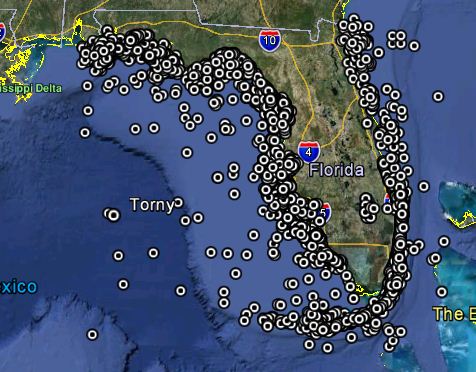 Over 5,000 Waypoints in 35 Coastal Counties, it's All About the GPS Numbers in Florida!
We have done our research and acquired GPS numbers
from multiple sources to bring you the most complete GPS reef charts available for PUBLIC fishing and diving reefs. Our reef site charts are cused for fishing, diving, spear fishing, lobstering and boating in Florida. Inshore fishing spots, offshore fishing spots, fishing reefs and blue water fishing spots. Until the advent of the internet, GPS coordinates for Florida reefs and shipwrecks, especially productive fishing spots, were tightly guarded secrets.Today, reef GPS coordinates of artificial reefs, shipwrecks, and natural patch reefs are public information readily available on governmental websites. Our reef charts are unique because we bring together the PUBLIC waypoints from dozens of sources AND for the highly regulated areas like The Keys, we have researched the rules for each site and include these rules in our waypoint descriptions. There are still "secret" spots out there but we do not have them on our charts. We have so many public spots to keep you busy, who cares about the secret ones!
![]() Why punch numbers into your GPS unit when you can import a whole regions numbers in minutes?
Why punch numbers into your GPS unit when you can import a whole regions numbers in minutes?
| GPS Coordinate Online Charts | ||
| Panhandle Florida Reefs | Big Bend Florida Reefs | Northeast Florida Reefs |
| Wakulla County - St. Marks | Hernando - Hernando Beach, Spring Hill | Nassau - |
| Franklin County - Apalachicola, Carrabelle | Citrus County - Crystal River, Homosassa | Duval - |
| Gulf County Reefs - Port Saint Joe | Dixie County - Horseshoe Bch, Suwannee | St. Johns - |
| Bay County - Panama City, Mexico Bch | Levy County - Cedar Key, Yankeetown | Flagler - |
| Walton - Miramar Beach, Seaside, Grayton | Taylor County - Keaton Bch, Steinhatchee | Volusia - |
| Okaloosa - Destin, Fort Walton Beach | Jefferson County Reefs | |
| Santa Rosa - Gulf Breeze, Navarre, Oriole | ||
| Escambia - Pensacola, Orange Beach | Oculina Bank NW on Flagler | |
| Central West Florida Reefs | Marine Protected Areas | Central East Florida Reefs |
| Pasco - New Port Richey, Holiday, Hudson Bch | Middle Grounds, The Ledges on Pasco | Brevard - Melbourne, Cape Canaveral, Coco Bch |
| Pinellas - Tarpon Springs, Clearwater, St Pete | Madison / Swanson on Gulf | Indian River - Vero Beach, Sebastian |
| Hillsborough - Tampa, Tampa Bay | Empire Mica on Gulf | St. Lucie County - Port St. Lucie, Ft Pierce |
| Manatee - Bradenton, Palmetto, Longboat Key | Pulley Ridge on Lower Keys | Martin County - Stuart, Hobe Sound |
| Sarasota - Sarasota, Siesta Key, Venice | Oculina Bank SW on Indian River | |
| Southwest Florida Reefs | The Florida Keys Reefs | Southeast Florida Reefs |
| Charlotte County - Pt Charlotte, Punta Gorda | Upper Keys - Key Largo, Islamorada | Palm Beach - Jupiter, Lakeworth, Boynton |
| Lee County Reefs - Fort Myers, Sanibel | Middle Keys - Marathon, Long Key | Broward - Ft Lauderdale, Pompano Beach |
| Collier County Reefs - Naples, Marco Island | Lower Keys - Dry Tortugas, Key West | Miami-Dade - Miami Beach, Key Biscayne |

The Most Complete List of GPS Coordinate Numbers for Florida Reefs, Wrecks, Islands & Holes Available Anywhere!
Our GPS Coordinate Lists are not only good for fishing but also snorkeling, diving, and boating. Our lists contain information compiled from multiple sources including:

- Florida Fish & Wildlife Conservation Commission's (FWC) master Artificial Reef List (which are materials "intentionally" placed for marine habitats)
- Reef Lists from each County in Florida
- Over 1,000 documented Shipwrecks
- Coordinates from The Office of Coast Survey's Automated Wreck and Obstruction Information System (AWOIS)
- Coordinates for marines zones, shipwrecks, buoys and FKNMS assets from NOAA, Florida Keys National Marine Sanctuary
- Offshore Holes and Ledges from topographic resources
- USGS Coordinates for Bars and Islands
- GPS Waypoints of Ports, Buoys, and other areas of interest
- Dozens of internet websites and books were used, providing missing information and details on reef sites
For the full list of resources, see below Sources section.
We Will Keep You Up-to-Date
 Reef sites are constantly being deployed in Florida. We stay in touch with FWC and local counties then pass on new site information to you via our online charts and our popular newsletter. Reef Reports submitted by users also help us keep our charts accurate. We indicate on our online charts "New!" for new deployments or updated information, so be sure to visit often. Join our Monthly Newsletter to receive updates on new & existing reef sites, breaking news, and information not always found on our website.
GPS Reef Chart Features
The Latitude/Longitude format listed on our charts is in Decimal/Minutes (DDMM.MMM) format. For instance 2850.642 would be 28 degrees, 50.642 minutes or 28 50.642 N. It is not in degrees, minutes and seconds format.
Deployment dates for reefs are the approximate date artificial reefs were placed, the date a vessel sunk, or the date discovered. The older the reef, the more established it is with marine life.
Datum is North American Datum of 1983 (NAD 83).
We use Symbols to indicate information on the sites such as if you can fish from a mooring buoy. We also include links on the site names where you will find more information on the site. We include these for those boaters that wish to snorkel or dive these sites and to eliminate the guess work. Since the laws in Florida change frequently, always inquire locally before fishing an unfamiliar site. Using our GPS numbers is at your own risk and coordinates are not guaranteed.
You must also keep in mind that wrecks can be dispersed around the charted area or gone due to hurricanes, strong currents, and bad weather.
Loran Converted Numbers
Many GPS coordinates have been converted from "Loran" to GPS and may be off the approximate location due to the conversion calculation results. There is no program or formula to accurately convert the numbers from this decommissioned system. With this in mind, reef GPS coordinates may not be 100% accurate so we cannot guarantee their exact location. We have included a column on our reef charts noting the sites that are PA (position approximate) which are sites that were converted from the old Loran system. Please send us a Reef Report if you visit a site and confirm the numbers or have the correct coordinates so we can update our charts. For an introduction read our Loran GPS DPGS Explanation article.
PLEASE NOTE:
- Not for Navigational Use. These Number Are Not Guaranteed. There are No Warranties Expressed or Implied.
- Due to the Increased and Severity of Recent and Past Hurricane Activity it is Very Possible These Numbers May Be Off.
- Rules change frequently, always inquire locally before fishing, lobstering, or spearfishing.
Multiple resources were used to create our Florida GPS Coordinates Reef Charts. This data is provided as a tool to increase your fishing and/or diving enjoyment and is not intended to be used for navigational purposes. This information is provided only as a courtesy and there is NO guaranties, warranties, express or implied, or representations as to the accuracy of this content. Florida Go Fishing assumes NO liability or responsibility for any errors or omissions in the information contained here. If you find an error or omission in the data, please feel free to contact us with the correct information and we will verify the error or omission and correct it as soon as possible.
For tips and techniques of fishing offshore reefs and wrecks visit Fishing Reef & Shipwrecks and Fishing Offshore.
Sources for GPS Coordinates and Reef Site Diagrams
We used dozens of resources to create our GPS coordinate reef charts. We also use contributions from volunteers through reef reports received updating and confirming coordinates. The following organizations are major contributors of GPS coordinates for our lists and this list is not conclusive.
- Florida Fish and Wildlife Commission, Division of Marine Fisheries Management, Florida Artificial Reef Program
- Florida Fish and Wildlife Commission, Division of Law Enforcement, Marathon Field Office
- National Ocean Service, National Oceanic and Atmospheric Administration, US Department of Commerce, Office of Coast Survey
- National Ocean Service, National Oceanic and Atmospheric Administration, US Department of Commerce, Florida Keys National Marine Sanctuary
- US Geology Survey
- South Atlantic Fishery Management Council
- Gulf of Mexico Fishery Management Counci
- Miami-Dade County Permitting, Environment, and Regulatory Affairs, Restoration & Enhancement Section
- Broward County, Natural Resources Planning and Management Division
- Palm Beach County, Environmental Resources Management
- Mexico Beach Artificial Reef Association
Our data files and listings on this website are unique because we have brought the data from dozens of resources into one place. We also include rules and regulations for many reef sites, a unique feature not found elsewhere. Please be aware that our GPS coordinates are a compilation of publicly available waypoints. We make NO representation or claims that our coordinates are exclusive, secret, not found anywhere else, etc.


