
The Keys Parks & Preserves
Locations >The Keys > Parks & Preserves | Upper | Middle | Lower
The entire Florida Keys is within the Florida Keys National Marine Sanctuary (FKNMS). Within the FKNMS are numerous national and state parks with their own set of rules on fishing, diving, and boating. We cover the FKNMS in our Reefs & Shipwrecks for the Keys.
Shipwreck Trail 
 Florida Keys National Marine Sanctuary's Shipwreck Trail includes 9 historic shipwrecks throughout the Keys. These historic shipwrecks were selected for their interesting historical significance. Some are old, some are not so old, but all offer divers a great destination. Most sites you can fish and all are great dive sites.
All Shipwreck Trail sites have mooring buoys, some allow fishing and sprearfishing.
| Sunk | Name | Description | Latitude | Longitude | Depth | Relief |
|---|---|---|---|---|---|---|
| 1917 | City of Washington |
25 08.786 | -80 15.354 | 25 | ||
| 1942 | Benwood |
25 03.144 | -80 19.93 | 40 | 15 | |
| 1987 | Duane |
24 59.38 | -80 22.92 | 118 | 50 | |
| 1985 | Eagle |
24 52.184 | -80 34.217 | 110 | 40 | |
| 1733 | San Pedro |
24 51.802 | -80 40.78 | 20 | ||
| 1889 | Adelaide Baker |
24 42.179 | -80 53.676 | 25 | ||
| 1986 | Thunderbolt |
24 39.663 | -8057.784 | 118 | 60 | |
| 1842 | North America |
24 38.265 | -81 05.607 | 14 | ||
| 1972 | Amesbury |
24 37.397 | -81 58.912 | 35 |
Indian Key Historic State Park ![]()
 |
| Source: https://www.floridastateparks.org/park/indian-key |
Indian Key is an island located Oceanside of US 1 at MM. 78.5 in Islamorada. This island was originally purchased by Jacob Housman in 1831 and was the hub for his wrecking and salvaging empire. Later the the first county seat for Dade County in 1836. Today it is a state park accessible only by boat.
You can enjoy hiking trails, learning the history of the island, and fish from the shore. Fishing within 100 feet of the dock is prohibited. There are mooring buoys on the west side of the island for day use.
Surrounding the island are grass flats and to the east of the island is the Indian Key Channel. The water depths are shallow, mostly less than 10 feet, so care should be taken to avoid prop damage to the protected sea grasses. No spearfishing as this island is in state waters.
John Pennekamp Coral Reef State Park ![]()
![]()
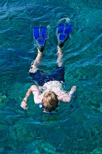
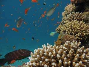
A very popular destination is the John Pennekamp Coral Reef State Park located at Mile Marker 102.5 Overseas Highway. This park is the first undersea park in the United States and encompasses 70 nautical square miles. This state park offers full facilities with beaches, diving, snorkeling, camping, a boat ramp, picnic areas, hiking trails, boat rentals, and boat tours. Located between 3 and 8 miles offshore off the coast are beautiful natural coral reefs, shipwrecks, and the famous Christ of the Abyss, located inside Key Largo Dry Rocks. Christ of the Abyss is an 8 1/2-foot-tall (2.6 m) statue of Jesus Christ weighs 4,000 pounds (1,800 kg) and sits in nearly 25 feet (7.6 m) of water.
Fishing in John Pennekamp Coral Reef State Park is allowed only in designated areas.
Visit http://www.pennekamppark.com for more information. ![]() John Pennekamp Diagram
John Pennekamp Diagram ![]() Lobstering in John Pennekamp Park
Lobstering in John Pennekamp Park
 |
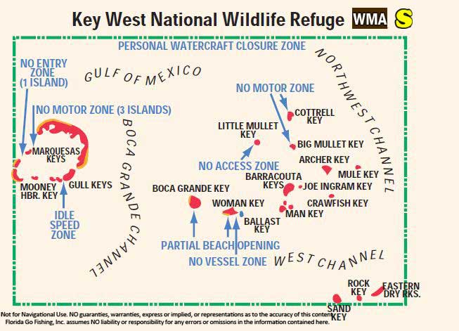 |
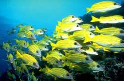
Great White Heron National Wildlife Refuge is a large area encompassing 7,600 acres of mangrove islands within over 200,000 acres of park boundries on the Gulf of Mexico side of the Keys from Bahia Honda to Key West. The Key West National Wildlife Refuge is west of Key West and is another large regulated area. These national wildlife refuges are set aside to help protect wildlife, especially nesting birds. You are allowed to fish, spearfish and lobster in these areas but no jetski's are allowed or dogs on the beach. There are markers/buoys indicating where you can and cannot enter throughout the areas with no-motor, no-entry zones, so be especially attentative when traveling these waterways. The areas are very shallow and groundings are always a possibility, so use your charts and your eyes. Flats fishing in these areas are very popular along with snorkeling on the shallow reefs which are abundant.
Bahia Honda State Park ![]()
![]()
![]()
 |
| Source: http://bahiahondapark.com/ guests-photo-gallery.cfm |
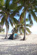
The 524 acre Bahia Honda State Park encompasses the Bahia Honda Key out to 400' into the Gulf of Mexico and the Atlantic and is located past Marathon at the end of the 7 mile bridge and east of Big Pine Key. Camping and cabins are available for extended stays at this pristine park. The park has 2.5 miles of sandy beach and offeres visitors hiking paths, snorkeling, kayaking and fishing. The park also offers 2 boat ramps and 19 boat slips with electric that can be rented for overnight stays. Fishing inside this park is easy with shore fishing or you can launch your boat from the parks boat ramp. The Old Bahia Honda Bridge offers fishing off the seawalls and the shallow flats on the Atlantic side offer chances for bonefish or permit. Spearfishing within the park is prohibited.
 |
| Photo Courtesy of National Parks Service |
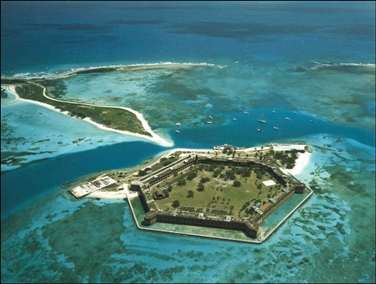
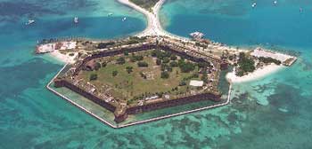
The Dry Tortugas are a remote string of 7 islands located at the west end of the Florida Keys, 70 miles (113 km) west of Key West and 37 miles (60 km) west of the Marquesas Keys, the closest islands. These sand and coral reef islands, or keys, along with 100 square miles of shallow waters and shoals that surround them, make up Dry Tortugas National Park. It takes about 2 hours by boat to arrive at the United States' most remote park and because of it's remoteness it is the least visited of our countries national parks.
The remote location and low human activity have allowed this area to remain pristine and unspoiled. The coral reefs and marine inhabitants provide an important living laboratory for research - the Nurse Shark research area is one such living lab. The park is an important stop over point for migrating birds from North to South America. Many birds nest here like the Sooty Tern and Brown Noddies; others stay such as the large Frigate birds seen soaring overhead year round. Loggerhead and Green Sea Turtles can be spotted on beach and swimming the shallow waterways. Natural reefs form on the edges of the fort and inside it's mote providing a kaleidoscope of colors seen easily seen from land. The clear waters reveal fishes both large and small, many with little fear of humans making snorkeling the most popular activity at the fort.
- Garden Key is open year round 24 hours a day.
- Fort Jefferson, on Garden Key, is open year-round from sunrise to sunset.
- Loggerhead Key is open to day visitors year round from sunrise to sunset. All other facilities on the island, including Loggerhead Lighthouse are closed to the public. Recreational vessels are allowed to beach at Loggerhead Key to visit the light house and view wildlife but no fishing is allowed at or near Loggerhead Key.
- Bush Key is open to visitors October 15th to January 15th from sunrise to sunset.
- Hospital Key and Long Key are closed year round and visitors should remain 100 feet offshore of all closed islands.
- Middle and East Keys are open to visitors October 16 to March 31 from sunrise to sunset.
- The RNA area is a 46 square mile no-take no-anchor ecological preserve. Allowed activities include boating, swimming, snorkeling, and scuba diving.
- Nurse shark research & breeding grounds is located to the Southeast of the park and is off limits June thought October.
- Coral Special Protection Zone located to the Southeast is closed to the public.
Collecting Is Prohibited: Do not remove seashells, coral, sand, brick, glass, stone, metal or any other natural or historic objects. If you find an artifact, do not move or disturb it, and call park staff.
Visit Dry Tortugas - 4 Ways to Get There
 Dry Tortugas National Park is a 70 mile trip from the closes port of Key West. Due to it's remote location you must carefully plan your trip.
Snorkeling and diving are popular activities for visitors arriving by ferry or seaplane service for day trips. The tour operators provide free use of snorkel gear as of this writing. You will also receive a tour of the fort when you arrive at Garden Key and your guide will tell you a history lesson during your journey to the islands..
There is a fee to visit the park and another fee for camping on Garden Key. If you arrive by ferry or seaplane service you will pay your fee before leaving Key West. If you arrive by boat there are self-service machines to take your fees.
There are no services on Garden Key where Fort Jefferson is located so visitors must plan to bring everything they need for the trip with them and when they leave take it all back to the mainland. Bring a cooler, water, suntan lotion, a change of clothes, and your diving or snorkel gear to see plenty of underwater life in the waters surrounding Fort Jefferson. Watch the video below to experience a day trip to Dry Tortugas.
Ferry Service
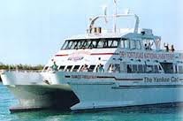 The Yankee Freedom II Ferry is the only commercial ferry service to Dry Tortugas and the source of most visitors to the park. Their service departs out of Key West daily at 8 am for a full day, round trip excursion costing about $165 per adult, returning to Key West a 5:30 PM. The ferry is a 100'x60' high-speed ocean-going catamaran taking 150 passengers on a comfortable 2 hour trip each way to Fort Jefferson. You will enjoy a full day on Garden Key - tour the fort, snorkel, dive, swim - or bring your camping gear and spend a night or more, returning to Key West on the next evening ferry of your choice. See camping below for more on camping.
Seaplane
A commercial seaplane service Key West Seaplane Charters departs daily from the Key West Airport for a 50 minutes plane ride each way. Not only is this the quickest way to get to Dry Tortugas, it is the most scenic. The view from the small seaplanes of the turquoise waters below is spectacular. The cost is steep at about $465.00 pp full day and $265.00 pp half day plus $5.00 park fee, tax, and tip. The half day trip does not give you enough time to tour the fort AND snorkel, so it is best to go for the full day where you can enjoy the whole Dry Tortugas experience. Once you arrive you will not want to leave! View the seaplane services video:
Private seaplanes are welcome as long as the required Special Use Permit is obtained prior to departure (allow at least 4 days for processing). Since the island has no fuel, only those who can fly the 150 mile round trip flight can make the trip. There is beach area for parking your aircraft.
Charter Boat
The fishing is fantastic in this very remote island chain. A charter guide knows where to go fishing in this highly regulated expanse of tropical waters. Many charters offer multiple-day excursions where you fish during the day outside of the park then overnight at Garden Key, either camping or sleeping on the vessel. See our Charter Boat page for charters offering trips to the Tortugas.
Your Vessel
 Unless you have a very large vessel that can make the trip in a few hours, your best bet is to plan on a multi-day trip for this 150 nautical mile adventure. A Special Use Permit is required to enter the park and should be obtained prior to departure (allow at least 4 days for processing). The only vessels exempt from this rule are those transiting the area without interruption. There is no fuel available so plan for a minimum 150 mile round trip plus time spent fishing and exploring in the park.
U.S. Coast Guard and Geodetic Survey Chart #11438 is necessary for navigation to the Dry Tortugas. Navigating the waterways from Key West to the national park should be done with extreme caution as the waterways are very shallow and riddled with reefs. Physical nautical chart and a GPS unit is important but your best navigation aid is your eyes! This area has the strong Gulf Stream current running by it causing constant shoaling, so nautical charts depth numbers are never accurate. Use extreme caution and travel to this remote area on good weather days.
Bring with your the most current paper nautical chart along with your GPS loaded with a pre-planned route into and out of the harbor area at Garden Key. If your vessel has dual switches for the batteries, run off one bank of batteries and keep one in reserve, alternating banks to refresh the charge occasionally. Since there is not cell phone service you will need a battery to fire up the VHF unit to call for help in this remote area with little boat traffic.
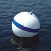 There are 7 mooring buoys around the park for day use. The mooring buoys and a boat dock on the island are free and are available on a first come, first serve basis with a 2 hour limit for use. You can also anchor in the designated sandy areas around Garden Key and bring your dingy ashore to visit the fort. Vessels may only anchor overnight within one nautical mile of the Garden Key Harbor Light on sandy bottom. If your boat is larger than 50 meters (164 feet) there are restrictions on anchoring, so inquire before arriving in the remote area. Visit Boat Slips page for more on docking on Garden Key. For a little privacy many boats anchor off Bird Key in the designated anchorage area indicated on the above charts.
 ![]() Dry Tortugas National Park Mooring Balls Rules
Dry Tortugas National Park Mooring Balls Rules ![]() Diagram of Garden Key
Diagram of Garden Key
 Most make this trip a minimum of a two night stay, either camping on Garden Key or staying on their own boat.
Think of the trip in terms of a survivalist's trip and be sure to bring everything you need to survive the duration of your trip. Bring plenty of fresh water for your time there, more than necessary as you will need it for drinking, bathing, meal prep, etc. Dry bags or ziplock bag at a minimum are necessary to protect gear like cameras, GPS, handheld VHF radios. A portable grill is necessary for cooking up your catch.
GPS Coordinates to Dry Tortugas
You will need GPS coordinates of boundaries in the Tortugas area if you will be fishing. We have done a lot of research and identified all the zones in the area, with GPS numbers of boundaries & rules.
GPS File Downloads ![]() PDF
PDF ![]() KML
KML ![]() GPX
GPX ![]() New! Buy our handy PDF file loaded with 78 Florida Keys diagrams
New! Buy our handy PDF file loaded with 78 Florida Keys diagrams
![]() National Park Service
National Park Service
Everglades City NPS (305) 242-7730
For fishing from your own vessel in the Tortugas, see the section below.
Things to Do in Dry Tortugas
Snorkeling & Diving
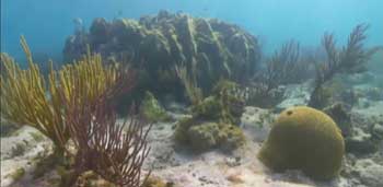
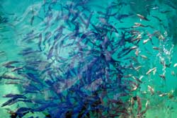
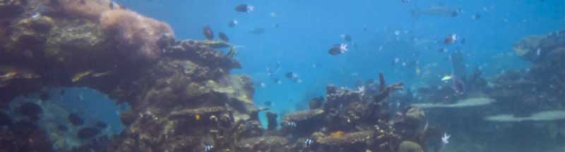
 In the Dry Tortugas, the coral reef is so close to the islands that snorkelers are able to swim over the reef directly from the beach. Snorkeling around Garden Key is excellent right off the beach in 15 feet of water, accessible to snorkelers of all levels. One of the most popular snorkel areas is located about 75 yards from the western edge of the moat wall. This area contains large coral heads, tropical fish, sea grass and other marine life. Here you can also explore the South Coaling Dock Ruins which contain the metal pilings of old coaling docks.
You must display a dive flag outside of the designated snorkel areas. Be aware of possible strong currents that are common in this area where the Gulf Stream skirts the Tortugas; it is advised that only strong swimmers venture away from the safety of the Garden Key shallow (4' to 7' deep), protected waters.
 For those with their own vessels, be sure to visit Little Africa on the west side of Loggerhead Key, about 2 1/2 miles from Garden Key harbor. You can anchor in front of the Loggerhead Key dock in the big sandy area and dinghy around Loggerhead Key or dinghy to the near shore and walk across, where you land your craft depends on the wind and waves.
There are many shipwrecks in The Dry Tortugas including the Windjammer, the East Key Wreck, and the Brick Wreck. The locations of many shipwrecks at Dry Tortugas are not publicized in order to prevent resource-damaging activities such as looting or caching of artifacts. With the park's dynamic environment (shifting sands, heavy rains), artifacts emerge on a constant basis. Due to the historical importance of leaving artifacts in place, please do not remove any artifacts you find and report them to park staff.
The Windjammer wreck is a great snorkel and dive site - you can get a waterproof diagram of the wreck at the gift shop. Another popular dive site is the Tortugas Bank with it's sparsely visited coral reefs. ![]() Map of the Windjammer Site
Map of the Windjammer Site
Kayaking
Kayaking is a wonderful way to explore the park. A Special Use Permit is required to kayak the park and should be obtained prior to departure (allow at least 4 days for processing). You must check in with a park ranger before departing-he will give you a quick briefing before you depart.
This is a vast area with few people near by so you must plan and be prepared for all unfrozen events. Be sure to have a portable VHF unit stored in a dry bag - this is a must. Read the National Park Service brochure Kayaking the Dry Tortugas which is a great planning guide.
Camping
 Camping on Garden Key is a fun, wild adventure for those who enjoy the solitude and want to feel like they are stranded on a deserted island. Once the tourists leave for the day, the island is isolated and very quiet. You can pitch your tent, grill your fresh catch, enjoy the wildlife and your solitude. You must bring all your survival gear - food, water, shelter, first aid kit, and trash bags. What you bring must go home with you, there are no trash facilities on the island.
What can campers bring with them on the commercial ferries? Campers arriving aboard the Yankee Freedom II are limited to 60 lbs. of gear plus water. The ferry does not allow the transport of fuels such as propane, lighter fluid, or any other type of liquid fuel or gas. Instead, self-starting / lighting charcoal is recommended. Visit the Yankee Freedom website for more details and instruction on camping.
For Brochures on Camping, Kayaking, Boating, and Planning Checklists, visit NPS Brochures webpage.
Park Layout
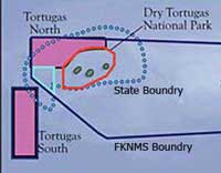 The FKNMS (solid black lines) and the Florida state boundary lines (blue dotted lines) are shown in the diagram to the left. State fishing rules apply in the state boundaries and the Gulf of Mexico federal rules apply in all other areas outside state boundaries. This area is also regulated by the National Park Service and has it's own special set of rules for fishing and we indicate these on the first diagram below.
On the below diagram you can see the two Ecological Reserve areas (green areas) which should be avoided and fishing is prohibited. The ER area on the lower left is outside the FKNMS boundaries and is a recent addition to the ER area's of the Dry Tortugas. Both ER areas require an Access Permit to enter the area or use a mooring buoy; you may pass through this area without stopping and all spearing gear must be broken down and stored.
No collecting, fishing, spearfishing or Lobstering inside the RNA area indicated in red below with the exception of Garden Key which allows fishing within a 1 mile radius of the key if you have a current State of Florida salt water license.
The purple outline on the first diagram indicates the National Park boundaries. Hook and line fishing is allowed outside the red RNA area within the park but no spearfishing or Lobstering inside the purple park boundaries. If you spearfish or lobster outside of park boundaries and will be returning to the park with your catch you must report your catch to the park ranger on VHF 16 before reentering and also have all spearing gear broken down and stowed away. Studying these diagrams will give you a good idea of the lay of the land in this remote park.
 |
 |
 |
 |
![]() NOAA Nautical Chart 11438: Dry Tortugas; Tortugas Harbor
NOAA Nautical Chart 11438: Dry Tortugas; Tortugas Harbor
Fishing in Dry Tortugas
Planning Your Fishing Trip
 Planning is everything for this remote fishing spot. Preparing your Vessel for the trip is discussed in the section above.
Before you go, studying bathymetric charts of the area combined with GPS coordinates of known fishing areas will give you a good idea of the lay of the land. We have details and diagrams in the Park Layout section above of the areas you can fish inside and outside the park.
Bring along a Florida Saltwater Fishing Regulations brochure to use for quick reference of Florida rules. Anglers in this area are limited to the possession of one day's bag limit, per angler, no matter how many nights that they stay at Garden Key. The exception to the rule applies to anglers fishing on head boats that travel into the park's waters- they can have two days' bag limits in their possession.
Operators of vessels that possess lobster or speared fish are asked to contact park staff via VHF 16 and declare catch they are bringing into the park. All spearing gear must be broken down and stowed away inside the park.
 Ice and Fish Chum are two items you can never have enough of since there are no marina's or bait shops once you leave Key West. Garden Key only has a small gift shop, nothing else. Dry Chum and Dry Ice are great backups that are light weight and don't take up much room.
Bring along some frozen bait to use as cut bait - Ballyhoo (jigging and trolling), Cigar Minnows, Spanish Sardines, Threadfins and Squid. If you have the time before you leave Key West net some Pinfish on the grass flats and in the spring grab some Ballyhoo in the grass flats and channels around Key West.
Bait fish may be taken by cast net only within 1 mile of Garden Key, limit of five gallons per vessel - look for bait schools around structure. You can also catch fresh bait outside of the park boundaries such as Grunts and Blue Runners which are plentiful in the area.
Bring big lipped lures for trolling for Grouper and Snapper, wire and lead egg sinkers for bottom fishing Carolina rigs. Jigging for bottom fish with whole dead Ballyhoo, butterfly baits and plastic tail works work great on the reefs especially when you are drifting.
Finding the Fish
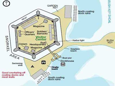
Garden Key allows fishing within a 1 mile radius of the key if you have a current State of Florida salt water license. From land on Garden Key fishing is permitted only from the dock and the shoreline immediately west of the dock. All other areas of Garden Key are closed to fishing. Fishing from a boat is permitted within a 1-mile radius of Garden Key. ![]() Diagram of Garden Key The following areas prohibit fishing:
Diagram of Garden Key The following areas prohibit fishing:
- The moat, moat wall, and within 300 feet of moat wall
- Vessels moored at the Garden Key Dock
- Helicopter pad area
- North and South beaches
Inside park boundaries but outside the RNA area (RNA indicated in red above; park boundaries indicated in purple) you are allowed to Hook and Line fish. Outside of all park boundaries you can fish, lobster and spear. Be sure to study the above charts to avoid fishing in prohibited areas.
When travel the waterways in search of your fishing spot, look for 4 to 10 foot relief on your fish/depth finder and you will find a good place to drop your anchor (in the sand) and start chumming. Here is a short list of popular areas to fish in the Tortugas:
- Within the 1 mile radius fishing zone around Garden Key are fishable wrecks, ledges and bottom structures that hold sizeable Mangrove Snappers, Yellowtails, Amberjack and Grouper.
- The fishable waters in the east half of the park are great for Grouper and Snapper in 40 feet of water.
- Outside the park in Federal waters on the Atlantic side in 60 to 100 feet you will find Yellowtails, Mutton Snapper, Black Grouper, Porgies, Hogfish and Mangrove Snapper.
- The area around the southern boundary of the park in 70 to 90 feet of water has a muddy bottom and not very productive for fishing.
- About 10 miles from the fort (45 minute ride) in 200 to 300 feet of water on the Gulf Steam you can fish the weed lines, especially in the summer months, for Sailfish and Dolphin.
- The Tortugas Bank is another great area for fishing, read all about it below.
- Swordfishing is great south of the Tortugas on the deep drop off at the edge of the continental shelf in the Gulf Stream. May anglers will travel to Garden Key, rest up and venture out at night and Swordfish, trolling with the Gulf Stream back to Key West.
.
Tortugas Bank 
 The Tortugas Bank is the western most stretch of coral reefs in the Tortugas and the Florida Keys, though none of it actually sticks out above water. The southern part of the bank is outside of the ER area so fishing, lobstering and spearing is allowed here. Remember, no lobstering in state waters on artificial structure - the Bank is in state waters!
Tortugas Bank is located just west of the Dry Tortugas National Park, just over 8 miles (14 kilometers) from Loggerhead Key. The shallowest depth on the Tortugas bank is 36 feet deep (11 meters). In the center of the bank you can find a circle of bank that is 59 feet deep (18 meters). Everything else is at least 66 feet deep (20 meters).
Divers can enjoy in the beautiful coral reef formations that are found at the Tortugas Bank. Anglers will find a large variety of fish in this remote area. Coral reef profiles are high with large overhangs, caverns and large swim trough. The water depths range from 45' to 80' with an average visibility of 50' to 120'. Currents are moderate to strong.
Anchoring should be done in sandy areas away from reefs. Vessels 164 feet (50 meters) or greater in registered length, are prohibited from anchoring on the portion of Tortugas Bank within the FKNMS west of the Dry Tortugas National Park that is outside of the Tortugas Ecological Reserve.

History of Dry Tortugas & Fort Jefferson
 Throughout the centuries the remote and dangerous shoals and islands of the Dry Tortugas have been a source of interesting maritime history including piracy, privatizing, smuggling and slaving. There is currently over 200 recorded ships sunk, stranded, or damaged in the Dry Tortugas due to the navigational hazards associated with this dangerous shallow reef track. Could this be why not a single shot was ever fired over the centuries between the fort and a enemy ship? Here is a brief history of the area:
1513: Spanish explorer Ponce de Le?n discovered the remote islands naming them Las Tortugas (The Turtles) due to the abundance of sea turtles. Spanish historian Antonio de Herrera wrote:
"They reached the chain of islets which they named Tortugas [turtles], because in a short time of the night they took, in one of these islands, a hundred and sixty turtles, and might have taken many more if they wished, and also they took fourteen seals [probably the Caribbean monk seal, extinct since the 1950s], and there were killed many pelicans and other birds, of which there were five thousand."
Soon after the islands were added to charts and the word "Dry" was added to the name to indicate the lack of fresh water as a caution to mariners. Ponce de Le?n only spent one day fishing turtles in the Tortugas then departed to discover the Straits of Florida and the Gulf Stream.
 Prior to 1600: Spanish fleets returning to Spain from Vera Cruz sailed around the Gulf hugging the shore and passed the Tortugas. Major shipping routes between the Gulf, Atlantic and the Caribbean, drew many ships close to the dangerous Tortugas reefs and left behind material remains of war and commercial wrecks. The Tortugas was also used as an anchorage for pirate ships who would attack vessels traveling the popular shipping channel.
1622: The earliest recorded shipwreck in the Dry Tortugas was the Spanish Plate Fleet including the Atocha.
War of 1812: The US begins constructing coastal fortifications from Maine to Texas.
1821: United States acquires Florida.
1825: The lighthouse on Garden Key is constructed to warn sailors of the rocky shoals.
1832: "John James Audubon visited the Dry Tortugas in 1832, noting that the colonies of sooties and noddies were heavily exploited for food by "eggers" from Havana. He also noted that the eggs (and birds) were extremely good eating and much enjoyed by the crew of the government vessel that carried him. (The great naturalist and painter who practiced ornithology through the barrel of a gun was no sentimentalist when it came to obtaining specimens for his paint palette or his soft palate.)"
Except from http://www.yankeefreedom.com/about-dry-tortugas-news-tortugas-triangle.htm
1846: The construction of Fort Jefferson was begun to fortify the Tortugas and control navigation to the Gulf of Mexico shipping lanes and protect Atlantic bound Mississippi River trade. In 1846 Congress awarded $200,000 for the Florida Reef fortifications. An inexperienced Horatio Wright, a West Point graduate from Connecticut, was award the charge of constructing the fort. It took Wright four months to prepare for his assignment and on December 1, 1946 he set sail on the 110-ton schooner Activa from New York harbor with a crew of six, a clerk, a mason and a carpenter. It took 15 days to arrive at the uninhabited group of islands called Dry Tortugas. Read A Constructional History of Fort Jefferson (this was on the NPS website at the time of writing) for the rest of this fascinating story written in 1961.
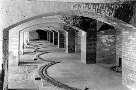
The hexagonal shaped fort, designed to hold 1,500 soldiers and 450 cannons, covers 11 of the 16 acres of land on Garden Key. With 8 foot thick, 45 feet high walls and over 16 million bricks used in it's construction, the fort is the largest coastal fort in America and the largest masonry structure in the Western Hemisphere. Slave labor was used during the Fort's construction along with craftsmen and laborers of Irish and other ethnic descent. The fort was never completed; concerns of structural weight on the reef and the invention of the rifled cannon made the fort obsolete because the walls could now be penetrated. Over the years the fort was used as a coal station, a quarantine station, and a prison.
1860: A handful of troops were stationed at the Fort Jefferson before the Civil War began.
1861?1865: During the Civil War, a thousand troops occupied Fort Jefferson which was now being used as a military prison for captured deserters and criminals. The most famous prisoners were four men convicted in the assassination of President Abraham Lincoln in 1865 (Mudd, Sam Arnold, Michael O'Laughlin, and Ned Spangler) and a political prisoner, George St. Leger Grenfell. Dr. Samuel Mudd was the most famous, he was found guilty of setting the broken leg of John Wilkes Booth after he had fatally shot Abraham Lincoln. Dr. Mudd was pardoned in 1869 due to his work in the Yellow Fever epidemic of 1867 at the fort. The cell above the sally port where Dr. Mudd was incarcerated after an escape attempt was opened to the public in 2002. Here, on the second tier of the fort, there is a small, excavated trench that he and other prisoners made to drain water so that they could sleep on a dry floor. It is a powerful sight and speaks volumes about prison life.
Also during this period the Union Army contracted with mainland slaveholders the use of their slaves to continue construction and repair of the fort, handing over any wages earned by the slaves to their owners.
1867: Yellow fever epidemic at Fort Jefferson.
1874: The US Army abandoned Fort Jefferson after years on construction problems and Yellow Fever epidemics.
1898: The Navy reopened the fort to use it during the Spanish-American War. The Dry Tortugas served as a harbor and staging area for ships in the area.
1908: The Dry Tortugas became a wildlife refugee, designated a bird reserve and transferred to the Department of Agriculture, to protect nesting birds from egg collectors. President Theodore Roosevelt declared these islands "Dry Tortugas Keys Reservation".
1914 - 1918: Fort Jefferson was used briefly during World War I as a seaplane base.
1922: The Dry Tortugas Keeper's Residence was constructed to provide much-needed residential living space for the principal lighthouse keeper and his family during a period of modernizing the Light Station.
1935: President Franklin D. Roosevelt created Fort Jefferson National Monument ? the first marine area to receive that designation. It was also coined the "Worlds First Underwater National Park".
1939 - 1945: Fort Jefferson was used as an observation post during World War II. The USCG recruited the Lighthouse Keeper to patrol the beaches and lookout for German U-Boats in the Florida Straits.
1992: Dry Tortugas receives it's current status of National Park to protect both the historical and natural features in a bill signed by President George Bush.
1990's to Today: Loggerhead Key has been a popular landing place for Cuban Refugees who are held at the fort then processed in Key West.
Today: Ongoing preservation of Fort Jefferson is needed due to the effects of age, weather. Read this NPS Bulletin on the ongoing repairs to this magnificent fortress in the middle of the sea.
Other Interesting Facts
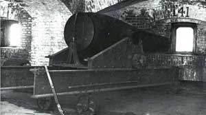 Fort Jefferson's Totten Shutters: During the construction of Fort Jefferson, protective iron shutters were installed within each of the fort's cannon openings, or embrasures, along the bottom tier. 2,000-pound iron support jambs on either side of the embrasure, was embedded in the surrounding brickwork. Developed in the United States in 1857, these innovative shutters were used in numerous American coastal forts. Their purpose was to protect cannon crews inside the gun rooms from enemy fire (specifically from shell fragments, small arms fire, and other smaller ordnance). The harsh salt -air environment of the Tortugas, however, caused the shutters and supporting ironwork to severely corrode over time. Not only is this corrosion unsightly, it has also led to the widespread loss of historic fabric. A major component of the fort's ongoing stabilization is to remove the deteriorating Totten shutters and embrasures, and repair the damaged brick. As of 2003, 45 of 147 Totten shutters and embrasures have been removed. Rather than use iron replacements, which would eventually corrode and again require removal, the park has used brick to create a representative cannon opening. During discussions with the SHPO in 2003, it was agreed that fiberglass reproductions of Totten shutters and embrasures would create a much more accurate appearance.
The rusting ruins of two Coal Rigs can be seen on the north and south ends of Garden Key. The Coal Rigs were build by the Navy Department at the turn of the century. When the fort was abandoned in 1906 the rigs were dismantled, usable apparatus and metal was salvaged and the buildings removed.
Heating Cannon Balls? Cannon balls were heated in a furnace type room where the balls rolled through a furnace and were heated red hot. The heated cannon balls would not only damage the wooden ships but would also set them on fire! This new warfare tactic was the beginning of the end of wooden ships.
The NPS's Shipwreck Study - The Dry Tortugas report from 1971 highlights the history of Florida, Key West, and Dry Tortugas. It is fascinating reading this recount of early observations of the treacherous waters surrounding the Tortugas, the very lucrative Wrecking industry that made Key West a very wealthy city, and the recounts of early shipwrecks. Read the recounts of shipwrecks starting on page 50. Wreckers, like cockroaches, would moor in Tortugas Harbor waiting for ships to flounder to stake their wrecking claim. Fascinating read!
Long Range Interpretive Plan 2003: This 150 page document has some very interesting information on the past and present state of the park. The document describes park visitors, plans for renovations with details on the history of each area and how they wish to replicate the past. Because of the parks remote location renovations are very difficult to accomplish and the source of funding even harder to acquire.
Recap of the Rules
 |
| Source: http://www.nps.gov/drto/index.htm |
We know the rules are very confusing in this highly regulated National Park. Here we recap the rules and also reprint the Official Rules.
All fishing is prohibited within the Research Natural Area (RNA), except within a 1-mile radius of Garden Key. Not included in the RNA is an area one nautical mile in diameter around the Garden Key Light, and the developed areas of Loggerhead Key. Garden Key fishing from shore is permitted only from the dock and the shoreline immediately west of the dock. All other areas of Garden Key are closed to fishing. Fishing from a boat is permitted within a 1-mile radius of Garden Key. Hook and line fishing is the only allowed fishing activity. Bait fish may be taken by cast net only; limit is five gallons per vessel. You are also allowed to use fish chum. Florida fishing rules must be followed and bag limits adhered to.
Spearfishing and Lobstering is allowed outside of the national park boundaries in Federal waters. If you will be returning to the park with your catch you must call the Park Ranger on VHF 16 to declare your catch and give them your vessel registration numbers. All spearing gear must be broken down and stowed away before reentering the park and the same goes for "just passing through" the park.
For more information:
Environmental Education Office 305-242-7753 or 239-695-4756
Park Ranger at Dry Tortugas National Park 305-224-4210
Here is a reprint of the "official rules":
Fishing for fin fish is permitted by closely attended hook and line gear only. All State of Florida saltwater fishing laws and regulations apply (except as modified below). Persons from vessels that have brought lobster or speared fish into park waters may only enter the water to swim from the designated swim beach on Garden Key. Spear guns must be broken down prior to entering the park. Spear fishing is prohibited in the park. See prohibited activities below. Bait fish may be taken by cast net only; limit is five gallons per vessel. In almost all cases it is illegal to possess more than one bag limit of any fish species. Avoid casting near sea turtles, and use circle hooks to avoid catching one. Report injured turtles to a ranger.
Prohibited Activities
Commercial fishing, spear fishing, use of a hand-held hook or snare (except when a gaff is used to land a fish lawfully caught), taking fish by sling or any powered gun, possessing conch, lobster, or ornamental tropical fish or marine life (unless taken outside the park), dragging or trawling a cast net or dip net, and collecting shells or artifacts from land or water are prohibited.
Park Areas Closed to Fishing
All fishing is prohibited within the Research Natural Area (RNA), except within a 1-mile radius of Garden Key ? see map on reverse. All Fish and fishing gear must be stowed prior to entry and during transit through the RNA. Operators of vessels that possess lobster or speared fish are asked to contact park staff via VHF 16 and declare catch they are bringing into the park. See "What is the Research Natural Area?" publication for more information on the RNA.
Garden Key Fishing
Fishing is permitted only from the dock and the shoreline immediately west of the dock. All other areas of Garden Key are closed to fishing. Fishing from a boat is permitted within a 1-mile radius of Garden Key. All the above mentioned regulations apply.
Rules for Commercial Fishermen
Persons in possession of commercially taken fish or commercial gear, or who are otherwise engaged in commercial fishing, may not fish within the park. Disposal of fish remains from commercial activities is prohibited. Anchoring commercial fishing vessels is limited to Bird Key harbor except in cases of emergency.
Multiple resources were used to create our Florida GPS Coordinates Reef Charts. This data is provided as a tool to increase your fishing and/or diving enjoyment and is not intended to be used for navigational purposes. This information is provided only as a courtesy and there are NO guaranties, warranties, express or implied, or representations as to the accuracy of this content. Florida Go Fishing assumes NO liability or responsibility for any errors or omissions in the information contained here AND is not responsible for location changes or inaccuracies of rules, bouys, hazards or markers. If you find an error or omission in the data, please feel free to contact us with the correct information and we will verify and correct it as soon as possible.


