
Hernando County GPS Numbers
GPS Coordinates > Big Bend > Hernando
 Hernando County offers fishing and diving opportunities with many artificial reefs
located
only
a few miles from shore. Hernando Beach and the 31,000 acres Chassahowitzka National Wildlife Refuge off excellent Tarpon fishing along with the usual inshore suspects. Hernando County has an excellent brochure showing their artificial reefs with headings.
Hernando County offers fishing and diving opportunities with many artificial reefs
located
only
a few miles from shore. Hernando Beach and the 31,000 acres Chassahowitzka National Wildlife Refuge off excellent Tarpon fishing along with the usual inshore suspects. Hernando County has an excellent brochure showing their artificial reefs with headings.
![]() Hernando County Waterways
Hernando County Waterways ![]() Central West Reefs & Shipwrecks
Central West Reefs & Shipwrecks
GPS Numbers File Downloads
![]() PDF
PDF ![]() KML
KML ![]() GPX
GPX
Click the Fishing & Dive Sites memory card image above to purchase Hernando County reef sites on a chip. The map below shows the reef site locations included and how they will look on your GPS unit. The site names, materials and rules are located inside the waypoint's description field. Visit Waypoints on GPS Units for more information.
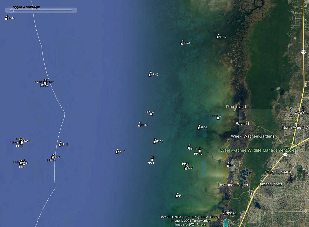
| Site ID / Reef Name | Materials / Description |
|---|---|
| HR-1 Aripeka Channel Entrance Light | 16' Tripod Light at end of Aripeka Channel 6s Flashing |
| HR-2 Gomez Rocks S | Pilings with Rocks in between |
| HR-3 Gomez Rocks N | Pilings with Rocks in between |
| HR-4 Minnow Creek Inlet | GPS Waypoint Hernando Beach |
| HR-5 Reef Ball Reef 2 | 26 Bay Balls 50 Pallet 2 Reef Balls |
| HR-6 Reef Ball Reef 1 | 65 Bay Balls 19 Pallet Balls 23 Reef Balls |
| HR-7 Reef Ball Reef | Yellow Buoy over 180 Reef Balls in 14 mile radius |
| HR-8 Billy Steele South Rack | Submerged Ruins and Light OCC 3c ON 1s OFF |
| HR-9 Richardson Reef | Concrete Rubble from Sunshine Skyway Bridge |
| HR-10 AH Richardson Buoy | Yellow Buoy |
| HR-11 Cutter Rock | Danger Rocks 6s Flashing Light |
| HR-12 Bill Watts Tripod | Quick Flashing Light at end of Hernando Beach Channel |
| HR-13 Hernando Beach Turn Light | 16' Tripod Light 3 second Flashing light |
| HR-14 AH Richardson | Concrete Culverts and Bridge Rubble |
| HR-15 Bendickson Reef - Tank 9 | Hernando Tank |
| HR-16 Bendickson Reef - Tank 1 | Hernando Tank |
| HR-17 Bendickson Reef - Tank 10 | Hernando Tank |
| HR-18 Bendickson Reef - Tank 6 | Hernando Tank |
| HR-19 Bendickson Reef 2 | Concrete Culverts |
| HR-20 Middle Rock | Sign - Danger Rocks to east |
| HR-21 Bendickson Tank Reef Buoy | Yellow Buoy over tanks in 14 mile radius |
| HR-22 Bendickson Reef - Tanks 8 | Hernando Tank 8 |
| HR-23 Bendickson Reef 1 | Concrete Culverts |
| HR-24 Bendickson Reef - Tank 2 | Hernando Tank |
| HR-25 Bendickson Reef - Tank 5 | Hernando Tank |
| HR-26 Bendickson Reef - Tank 4 | Hernando Tank |
| HR-27 Bendickson Reef - Tank 7 | Hernando Tank |
| HR-28 Bendickson Reef 3 | 250 sq feet Concrete Culverts |
| HR-29 Bendickson Reef 4 | 215 sq feet Concrete Culverts |
| HR-30 Bendickson Reef - Tanks | Hernando Tank |
| HR-31 Bayport Channel Entrance Light | Light end of Bayport Channel 5s Flashing |
| HR-32 Saint Martins Reef | Bar Reef Area |
| HR-33 Northwest Rocks | Island and Rocks |
| HR-34 Bayport North Rack | Submerged Ruins to North and West and Light ISO 3s On 3s Off |
| HR-35 Jim Champion Reef 1 | 650 cubic yards of Concrete Culverts |
| HR-36 Jim Champion Reef 2 | 40'x10'x5' Steel Barge 66 cu yds Concrete Culverts |
| HR-37 Jim Champion Reef 3 | 133 cubic yards Concrete Culverts |
| HR-38 Jim Champion Reef 4 | 100 cubic yards Concrete Culverts |
| HR-39 Jim Champion Reef Buoy | Yellow Buoy |
| HR-40 Fillete | 80' Vessel |
| HR-41 Chassahowitzka Channel Entr | Entrance to Channel Quick Flashing Light |
| HR-42 Chassahowitzka Reefs | Bar Reef Area |
| HR-43 Captain Gil | 60' Steel Tug |
| HR-44 Jackie M | Wreck |


