Upper Keys Reefs & Shipwrecks
Locations >The Keys > Upper Keys Reefs & Shipwrecks
![]() Middle
Middle![]() Lower
Lower ![]() GPS Coordinates
GPS Coordinates ![]() Maps of The Florida Keys GPS File Downloads
Maps of The Florida Keys GPS File Downloads ![]() PDF
PDF ![]() KML
KML ![]() GPX
GPX
 Key Largo to Islamorada up to Longitude -80 45
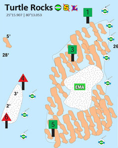
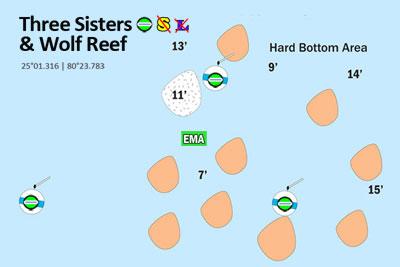
The shipwrecks, reefs, and wrecks in The Upper Florida Keys are the most visited in the world. We have added mooring buoy, fishing, spearfishing and Lobstering information to NOAA charts to clarify the rules. Every reef site has it's own set of rules, so be sure to study the site you plan to visit. Our diagrams below have large diagrams attached, just click the small diagram and a new window will open showing the reef site details.
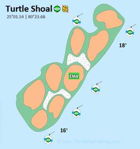
FKNMS provides mooring buoys at popular diving & fishing areas throughout the Keys to prevent anchor damage to reefs. If mooring buoys are present you must use them. If none are available and you cannot find another angler to tie up to, only anchor in a sandy area away from the reef. Some mooring buoys may be designated "fishing" buoys or "dive boat" buoys; it is proper courtesy to comply with these designations. We use green and red icons to indicate whether you can or cannot fish from the available mooring buoys at each site. We also indicate if you can or cannot spearfish and if there is no Lobstering allowed an icon will be on the diagram.
We have done the research for you and indicate on the below charts where you can and cannot fish, lobster and spearfish. Most sites where you can hook & line fish you can lobster - if Lobstering is not allowed we indicate it. ![]() Lobstering Brochure There is no spearfishing allowed from the Miami-Dade line until you get south & west of Rodriguez Key starting at approximately the Bibb wreck. See the spearfishing section below for more. There is no spearing in State Parks.
Lobstering Brochure There is no spearfishing allowed from the Miami-Dade line until you get south & west of Rodriguez Key starting at approximately the Bibb wreck. See the spearfishing section below for more. There is no spearing in State Parks.
![]() = Mooring Buoy(s) - OK to fish when tied to buoy
= Mooring Buoy(s) - OK to fish when tied to buoy ![]() = Mooring Buoy(s) - No Fishing when tied to buoy
= Mooring Buoy(s) - No Fishing when tied to buoy
![]() = Spearfishing OK
= Spearfishing OK ![]() = No Spearfishing
= No Spearfishing ![]() = No Lobstering
= No Lobstering ![]() Symbol Index Click Diagrams to Enlarge
Symbol Index Click Diagrams to Enlarge
New! Buy our handy PDF file loaded with 78 Florida Keys diagrams
|
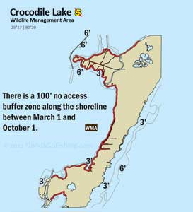
The 6,686 acre Crocodile Lake National Wildlife Refuge protects the endangered American Crocodile. Headquarters is 1.8 miles north of the Highway US-1 and County Road 905 split in Key Largo. |
Lake Surprise is just under the bridge leading to Key Largo on US 1. The eastern part of the lake is idle speed / no wake zone. |
 |
 |
|
No Lobstering per Florida Law Chapter 68B-24 |
|
|
Carysfort Trench is a deep trench north of the lighthouse. This older reef has double spur formation with staghorn, brain & sheet coral and large barrel sponges with deep ridges throughout. EMA no spearfishing. |
|
|
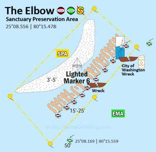
The Elbow is a bank reef with a spur and groove system and healthy deepwater corals located 6 nautical miles southeast of Key Largo. There are 2 mooring buoys to fish from outside the SPA area. |
|
 |
|
|
Molasses Reef is the most visited and most beautiful reef track in the Keys. This spur and groove system has many caves and offers both shallow areas for snorkeling and deeper areas in 100' for fishing. |
No Lobstering per Florida Law Chapter 68B-24 |
|
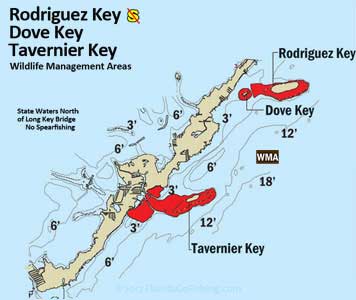
The flats around Tavernier Key are a popular fishing destination. Take note of the no-motor zones around these islands. |
|
|
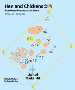
Hen & Chickens is a shallow reef of clustered corals with depths ranging from 6' to 18' and is located in the middle of Hawk Channel just off of Plantation Key. |
|
|
Cheeca Rocks is in State waters and North of Long Key Bridge so no spearfishing in this area. |
|
|
|
|
|
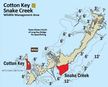
Cotton Key is off the northeastern tip of Upper Matecumbe Key and contains shallow flats with lots of bonefish. |
The above diagrams are courtesy of FKNMS. Florida Go Fishing created helpful icons and added site details to each diagram with rules.
Upper Keys reviewed by FWC Marine Patrol 6/4/2012
Spearfishing
Spearfishing is prohibited in all state waters north (east) of the Long Key Bridge and in all waters of the FKNMS contained within the Key Largo Existing Management Area which extends out to 300' deep water. The only spearfishing in the Key Largo area is in Federal waters south of Rodriguez Key or outside the EMA in more than 300' water. We indicate on the above diagrams whether you can or cannot spearfish to eliminate the guess work. South (west) of the Long Key Bridge, you are allowed to spear in both state and federal waters of the FKNMS as long as you are at least three miles offshore from the nearest point of land, not in a no-take zone (SPA's, Looe Key EMA, ER's, and ROA's). There is no spearing in State Parks. Its irresponsible to spearfish anytime recreational divers are present, so use good judgement when spearing.
![]() FWC's Spearfishing Regulations for rules & species restrictions and
FWC's Spearfishing Regulations for rules & species restrictions and ![]() Spearfishing Regulations in Monroe County
Spearfishing Regulations in Monroe County
Key Largo Existing Management Area 

The Key Largo National Marine Sanctuary was redesignated as a 103 square nautical mile Existing Management Area with six Sanctuary Preservation Areas spanning from Carysfort south to Molasses Reef.
The Key Largo EMA includes all state waters north (east) of the Long Key Bridge north to Key Biscayne extending out to 300' deep water. Spearfishing is prohibited in this area including in Federal waters. Hunters can spear past the EMA in over 300' of water or venture south (west) of Rodriguez Key where many dive boats take hunters to some great sites in this area. South of Rodriguez Key to Long Key Bridge (-80 51) you can spear in Federal waters that start after 3 miles after the furthest point of land.
While Monroe County allows spearfishing in Federal and State waters (3 miles out on Atlantic side, 9 miles on Gulf side) south (west) of Long Key Bridge, you must remain in continuous transit (do not stop) through waters north (east) of the Long Key Bridge and the Key Largo Existing Management Area when returning to port with gear broken down and stowed away.
Fishing is allowed outside of SPA and RO areas within the EMA. There are many sites with mooring buoys for anglers to fish while tied to the buoy from their boat as indicated on our charts above.
There are dozens of sites to dive and snorkel within the Sanctuary Preserve Areas (SPA) inside the Key Largo EMA. Due to their protected status you will find magnificent sea life with opportunities for photographing natural reefs, shipwrecks and the famous Christ of the Deep statue in John Pennekamp State Park.
Long Key Bridge to Rodriguez Key
No Spearfishing in State Waters - OK to Spearfish in Federal waters.
 |
| Click image to enlarge |
Aquarius at Conch Reef
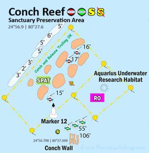
 Aquarius Reef Base is a NOAA underwater laboratory located at Conch Reef 3 1/2 miles offshore, 9 miles south of Key Largo. This laboratory is the only underwater facility of it's type in the world. This 81 ton, 43'x20'x16.5' facility houses scientists for 10 day durations and has all the comforts of home.
Watch this video to see Aquarius. Pay attention to the fish that inhabit the overhangs, fish love structure!
For more information on Aquarius visit Aquarius Reef Base. ![]() Conch Reef Site Diagram
Conch Reef Site Diagram
Benwood


 Located within the Key Largo EMA area, the Benwood Wreck is has mooring buoys available for anglers and divers. You can fish while tied to the mooring buoys, go lobstering, dive or snorkel, but spearfishing is prohibited in this area.
This 285 foot 1910 English-built ship sailed a crew of 38 with 12 rifles and one four-inch gun. The actual sinking of the Benwood, which occurred in 1942, has been a subject of much controversy. One account goes as follows. The freighter was torpedoed during World War II by a German submarine off the Florida Keys. As she sailed in search of shallower waters, she was again hit, this time by a passing ship, the Robert C. Tuttle, five shells on board exploded ending this ship's possibility for being salvaged. A second more likely account claims the two ships, the Benwood and the Tuttle, collided. Rumors of German U-boats in the area required her to travel completely blacked out. The Robert C. Tuttle, also blacked out, was traveling in the same area, bound for Texas. The two ships were on a collision course, and the bow of the Benwood collided with the port side of the Tuttle. 
After she sank, her bow was destroyed to avoid navigation hazards and her hull was used for bombing practice. The remains of her bow now lie in 25 feet of water and provide a home to many fish. Depths of this dive range down to 55 feet at her stern. Goatfish, grunts, moray eels, glassy sweepers, snapper, lobster, grouper and hogfish frequent this wreck. The site is home to a healthy collection of sea fans, sea whips, brain coral, sponges and fire coral. Be careful to avoid contact with the potentially harmful fire coral and with all corals as contact will result in damage to the organisms. The still and careful observer will be able to see tiny jaw fish emerge from their protected homes.
Bioluminescent creatures create the nighttime beauty of this location. Divers should be aware that a moderate current is often present at this site. Night diving is meant for the more experienced diver while divers at all levels will find this a great day-time dive. ![]() Benwood Site Diagram
Benwood Site Diagram
USS Bibb 

 The USS Bibb wreck is a former Coast Guard ship that saw extensive service to her country and took part in the invasion of Okinawa during World War II. The Bibb also served as a convoy escort, protecting cargo ships against enemy attack. The Bibb rests on her side in 130 feet of water six nautical miles offshore from Key Largo. The USS Bibb was built as a Campbell class cutter in the Philadelphia Navy Yard and commissioned in 1936 with a crew of 13 officers and 132 enlisted sailors. This class of ship was sometimes referred to as the "327s" due to their length and was named for former secretaries of the United States Treasury. The 327-foot vessel had a beam of 41 feet and drew 13 feet of water. The Bibb was armed with two 5-inch guns, 40 mm and 20 mm cannon for air defense. Twin screws gave her a top speed of 20 knots. After its launch in 1937,one of the first missions of the Bibb was to protect threatened Atlantic merchants from the aggressive tensions of the war in Europe. In 1942, the Bibb was outfitted with improved guns and enlisted into the service of the Navy for convoy escort duty. During her career, the Bibb rescued survivors from the S.S. Penmar and Henry S. Mallory, as well as being involved in the Vietnam conflict. Finally, she was decommissioned in 1985 prior to being sunk as an artificial reef.
 ![]() Bibb Site Diagram
Bibb Site Diagram
Carysfort / South Carysfort 


The Carysfort / South Carysfort SPA area is the largest at 1.5 square nautical miles and is the most remote reef system in the Upper Keys. This entire area is within the Key Largo EMA. Carysfort Lighthouse sits atop this well established double reef system of shallow corals which is perfect for snorkeling. South of the lighthouse is a large expanse of elkhorn coral forming South Carysfort reef. Further offshore are massive star corals over ridges, gullies and some swim through tunnels. Due to the remoteness of this area it is not frequently visited.
![]() Carysfort/South Carysfort Site Diagram
Carysfort/South Carysfort Site Diagram
Christ of the Abyss 


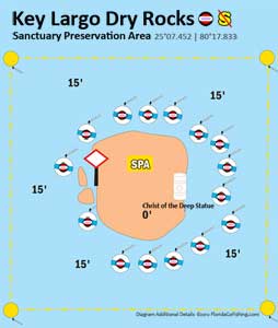
 The approximate nine foot bronze sculpture symbolizes peace of mankind from its unusual setting - beneath the ocean at Key Largo Dry Rocks off John Pennekamp Coral Reef State Park. The original casting was placed in the Mediterranean Sea at San Fruttuoso Bay near Genoa, Italy in 1954. It is known as the Il Christo Degli Abissi or in English - Christ of the Abyss. Professor Guido Galletti cast the original from the inspiration of Italian swimmer/diver Duilo Merchant who wanted a symbol to inspire all who explored and loved the sea in 1954. In 1961, the second casting from the original Galletti mold was placed in St. George's Harbor in Grenada to commemorate those saved from the Italian ship Bianca C. which caught fire and sank in the harbor. The third casting was commissioned by Italian dive equipment manufacturer, Egidio Cressi, and donated to The Underwater Society of America. The statute stands in 25 feet of water off of Key Largo, Florida. It is located near Dry Rocks, about six miles east-northeast of the Key Largo Cut, in the John Pennekamp Coral Reef State Park.
 ![]() Key Largo Dry Rocks Diagram
Key Largo Dry Rocks Diagram
CGC Duane 

 The U.S. Coast Guard Cutter Duane lies upright on a sandy bottom in 120 feet of water one mile south of Molasses Reef off Key Largo. After being decommissioned on August l, 1985 as the oldest active U.S. military vessel, the Duane was donated to the Keys Association of Dive Operators for use as an artificial reef.On November 27, 1987 she was towed to Molasses Reef, her hatches opened, her holds pumped full of water and down she went to begin her final assignment.
The Duane was built in 1936 at the U.S. Naval Yard in Philadelphia. She was a 327-foot long Treasury Class Cutter, one of seven such vessels, and was named for William J. Duane, Secretary of the Treasury under Andrew Jackson. She had various assignments before being sent to the Atlantic in 1941, where she eventually served with the U.S. Atlantic Fleet.  Her service included an impressive wartime and peacetime record. On April 17, 1943, she and her sister ship, the Spencer, sank the German U-Boat U-77. She participated in four rescues at sea, picking up a total of 346 survivors. In 1980 she was an escort vessel for thousands of Cuban refugees coming to the United States. Her last assignments included Search and Rescue work and Drug Enforcement.
On a clear day, the outline of Duane's intact hull can be seen from above. The mast and crow's nest, protruding high above the hull, can be seen at 60 feet. At 70 feet, just forward of amidships, is the navigating bridge. The superstructure deck is at 90 feet and the main deck lies at l00 feet. The hull structure, completely intact with the original rudders, screws, railings, ladders and ports makes an impressive display. ![]() The Duane
The Duane ![]() CGC Duane Photo
CGC Duane Photo ![]() Duane Site Diagram
Duane Site Diagram
The Eagle 

 The Eagle was built in Werf-Gorinchem, Holland by Bijker's Aanneming's Bedrijf, Ijssel under the title yard number 167. She was known by various names. Beginning on December 31, 1962 under the name Raila Dan, the Eagle was 268.5-feet long, 40.29-feet wide and 65-feet high. She was later named Barok in 1967. Seven years later, her name was changed again to Carmela. She was also known in 1976 as Ytai, Etai (1977), and Carigulf Pioneer (1981). She was purchased in 1984 by Jonaz Corporation Ltd. of Georgetown, Cayman Islands where she was named Arron K. Finally, she was christened Eagle Tire Co. in 1985 just before she was sunk. She carried mainly cardboard and newspaper between Miami and Venezuela. On October 6, 1985, 125 miles south of Miami, the ship caught on fire in route to Venezuela. The superstructure of the ship was totally destroyed. After only 23 years of use, she was retired and moored to the bank of the Miami River.
 On December 19, 1985, the Eagle Tire Co. was sunk by explosives at her present site about 4 miles south of Snake Creek in Islamorada.. She was supposed to sink beside the barge she was moored to, the sunken Alexander Barge, but the Eagle broke away from the barge, and the port anchor was dropped to prevent further drifting away. The decision was made to sink the Eagle where she had dropped anchor. Eagle settled on her Starboard side in 105' to 115' of water (depending on sand shifts & swales) with her bow pointing more or less NNW. The shallowest points of the wreck are at 65' - 70'. On September 25, 1998, Hurricane Georges broke the stern section & superstructure off the wreck and separated the sections by 20-30'. The hull shifted several yards & the stern section angles upward by 10 degrees or more. Most divers feel that this change has made the wreck a more interesting dive. There are several places where advanced wreck divers can penetrate the ship. It is generally well-lit and divers report seeing amberjacks, grunts, silversides, cobia, jewfish, and nurse sharks. The masses of coral that have grown on the ship are well-developed. Spiny oysters and sponges abound.
 ![]() The Eagle Shipwreck Trail
The Eagle Shipwreck Trail ![]() Eagle Site Diagram
Eagle Site Diagram
Grecian Rocks 

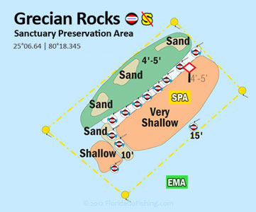
 Grecian Rocks is shaped like a half circle. The reef covers an area about half a mile long, and is inshore from the other reefs in this area. It has beautiful spur and groove coral formations that are covered with colorful corals and sponges . The crest of the reef is lined with fingers of elk horn coral and colorful tropical fish. There are areas where the reef is totally out of the water at low tide.
On the inside of this reef is a sandy flat expanse that is bordered with thick turtle grass areas. This part of the reef is shallow only 3' to 6' deep and there is good chance of seeing Queen Conch. The Conch moves around by motions called leaping and hoping. The Conch is protected, so look don't touch. Don't mess with them or pick them up. About 75' out from the reef on the south side is an Old Spanish Cannon. It was placed here several years ago by the park service.This dive site is a great one for snorkeling. ![]() Grecian Rocks Site Diagram
Grecian Rocks Site Diagram
Molasses Reef 


 Said to be the world's most popular dive site, Molasses Reef is kept clear by the Gulf Stream off the Atlantic coast of Key Largo. Populated with a very high concentration of animals and corals (especially star & Elkhorn coral), the reef's inhabitants are a good representation of life throughout the Keys. Look for vase sponges and the sea turtles that flock to them. Many coral formations are shallow enough to make great diving for novices, and spots drop to about 50 feet for the more seasoned explorers. The site got its name from a cargo ship that ran aground while transporting barrels of molasses, but divers can only see the remains of the Windlass wreck, also known as the Winch.
 ![]() Molasses Reef SIte Diagram
Molasses Reef SIte Diagram ![]() Molasses Depth Chart
Molasses Depth Chart
Spiegel Grove 

The Spiegel Grove wreck is one of the most accessible and popular dives in Key Largo. It's 510 feet long and lies in shallow enough water so that beginner divers can dive this wreck. The Spiegel Grove, nicknamed the Spiegel Beagle, had been decommissioned in 1989 after 33 years of service. With a beam of 84 feet and tonnage of 6,880 tons, she was gigantic and perfect for an artificial reef. She had been a Landing Ship Dock (LSD) so she was very broad. In fact, at the time of her sinking, she was the largest ship ever scuttled for an artificial reef.
It took almost a year to prepare the Spiegel Grove for sinking. The cost of the project went beyond $1 million, and she actually sank before workers were ready. Thousands of dollars' worth of equipment was lost as she flipped over in the water, leaving her hull sticking out of the water. Professional divers were hired to turn her over and sink her properly, and finally in 2002 a new reef was formed off Key Largo. A few years later during the hurricane seasons of 2004-2005, she was rolled over a bit and the mooring buoys were pulled under during Hurricane Dennis. They've been since fixed, however. It's now standing upright.
Spiegel Grove is very popular for diving but anglers love it as well. Fishing line is everywhere! It's very close to the Gulf Stream, so it attracts large fish, plus things like manta rays and hammerhead sharks On a clear day (meaning clear visibility in the water) you can see her from the surface. ![]() Spiegel Grove Site Diagram
Spiegel Grove Site Diagram
![]() Middle
Middle![]() Lower
Lower ![]() Symbol Index
Symbol Index ![]() GPS Coordinates
GPS Coordinates ![]() Maps of The Florida Keys
Maps of The Florida Keys
Multiple resources were used to create our Florida GPS Coordinates Reef Charts. This data is provided as a tool to increase your fishing and/or diving enjoyment and is not intended to be used for navigational purposes. This information is provided only as a courtesy and there are NO guaranties, warranties, express or implied, or representations as to the accuracy of this content. Florida Go Fishing assumes NO liability or responsibility for any errors or omissions in the information contained here AND is not responsible for location changes or inaccuracies of rules, bouys, hazards or markers. If you find an error or omission in the data, please feel free to contact us with the correct information and we will verify and correct it as soon as possible.


