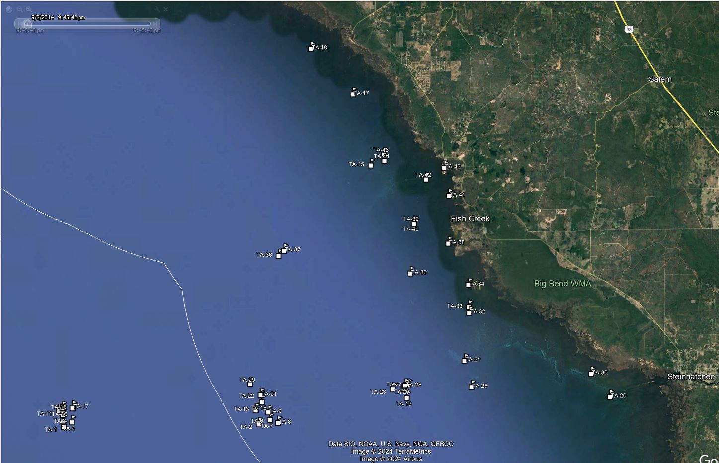
Taylor County GPS Numbers
GPS Coordinates >Big Bend > Taylor
 Taylor County offers 60 miles of coast line with an abundance of reefs, islands,
and fishing
areas. Fishing in and around scallop beds and oyster bars also offers
excellent fishing. You can also check out neighboring Dixie, Jefferson, or Wakulla counties for more GPS numbers.
GPS Numbers File Downloads
![]() PDF
PDF ![]() KML
KML ![]() GPX
GPX
Click the Fishing & Dive Sites memory card image above to purchase Taylor County reef sites on a chip. The map below shows the reef site locations included and how they will look on your GPS unit. The site names, materials and rules are located inside the waypoint's description field. Visit Waypoints on GPS Units for more information.

| Site ID / Reef Name | Materials |
|---|---|
| TA-1 Buckeye Reef Addition 3 | 27 Patch Reefs of 2 Towers 2 FH Units and 2 Juniors (162) |
| TA-2 SFMA Public Reef 8 | 24 Modules Concrete Cubes |
| TA-3 SFMA Public Reef 7 | 24 Modules Concrete Cubes |
| TA-4 Buckeye Reef Addition 2 | 25 FH Towers 25 FH Modules 13 Patch Reefs (50) |
| TA-5 Buckeye Reef Addition Culverts | 40 Concrete Culverts and Pipes |
| TA-6 SFMA Public Reef 4 | 16 Pre-Fabricated Cubes One Meter an a Side |
| TA-7 SFMA Public Reef 4a | 24 Modules Concrete Cubes |
| TA-8 Buckeye Addition South Patch | 4 Modules Concrete Cubes |
| TA-9 SFMA Public Reef 6 | 24 Modules Concrete Cubes |
| TA-10 Buckeye Addition Center Patch | 4 Modules Concrete Cubes |
| TA-11 Buckeye Addition West Patch | 4 Modules Concrete Cubes |
| TA-12 Buckeye Addition East Patch | 4 Modules Concrete Cubes |
| TA-13 SFMA-Public Reef 3 | 16 Pre-Fabricated Cubes One Meter an a Side |
| TA-14 SFMA Public Reef 3a | 24 Modules Concrete Cubes |
| TA-15 Buckeye Reef | 56 pcs Lg Scrap Steel from Buckeye Paper Mill |
| TA-16 Buckeye Addition North Patch | 4 Modules Concrete Cubes |
| TA-17 Buckeye Reef Addition 4 | 21 pcs Lg Metal Scrap Stuctures Buckeye Paper Mill |
| TA-18 SFMA Public Reef 5 | 24 Modules Concrete Cubes |
| TA-19 Steinhatchee Reef aka Steinh 1 | Scrap Metal and Concrete Rubble |
| TA-20 N Steinhatchee No.1 Buoy | Buoy |
| TA-21 SFMA Public Reef 2a | 24 Modules Concrete Cubes |
| TA-22 SFMA Public Reef 2 | 16 Pre-Fabricated Cubes One Meter an a Side |
| TA-23 401 Wreck | Unknown wreck |
| TA-24 Steinhatchee Reef aka Steinh 2 | 118 Cubes in L-Shape - South East Corner |
| TA-25 Little Bank | Fishing Area |
| TA-26 Steinhatchee Reef aka Steinh 3 | Concrete Culverts Mixed Metal Boiler Parts |
| TA-27 Steinhatchee Reef aka Steinh 4 | Concrete Culverts and Mixed Metal |
| TA-28 Steinhatchee Reef aka Steinh 5 | Steel Scrap and Steel Boiler Parts |
| TA-29 SFMA Public Reef 1 | 16 Pre-Fabricated Cubes One Meter an a Side |
| TA-30 Cape Saint George Shoal | aka Shell Reefs - Bar north side Deadman Bay |
| TA-31 Nine Mile Sandbar | Sandbar |
| TA-32 Grassy Rack | Bird Rack Platform |
| TA-33 Birdrack 3 | Culverts placed circularly around Birdrack |
| TA-34 Big Grass Island | Island |
| TA-35 Dog Head | Fishing Area |
| TA-36 Andree Reef 2 - Taylor 2 BB | 96 Pre-Fabricated Cubes 1 Meter on a side - Hexagon |
| TA-37 Andree Reef 1 - Taylor 1 BB | 24 Pre-Fabricated Cubes 1 Meter on a side - Hexagon |
| TA-38 Hagans Cove | Fishing Area |
| TA-39 Birdrack 2 | Culverts placed circularly around Birdrack |
| TA-40 Dark Island BR | Bird Rack Platform |
| TA-41 Dark Island | Island in Keaton Beach area |
| TA-42 Keaton Beach | Fishing Area |
| TA-43 Marker 1 - Keaton Bch Channel | Fishing Area |
| TA-44 Dekle Rack | Bird Rack Platform |
| TA-45 Trout | Flats Fishing Area |
| TA-46 Birdrack 1 | Culverts placed circularly around Birdrack |
| TA-47 Adams Beach | Fishing Area |
| TA-48 Spring Warrior Creek | Fishing Area |
| TA-49 Pitts Creek | Bird Rack Platform |
| TA-50 Rocky Point | Bird Rack Platform |
| TA-51 Big Bayou | Bird Rack Platform |
| TA-52 Rock Island | Fishing Area |
| TA-53 Fenholloway River | Fishing Area |


